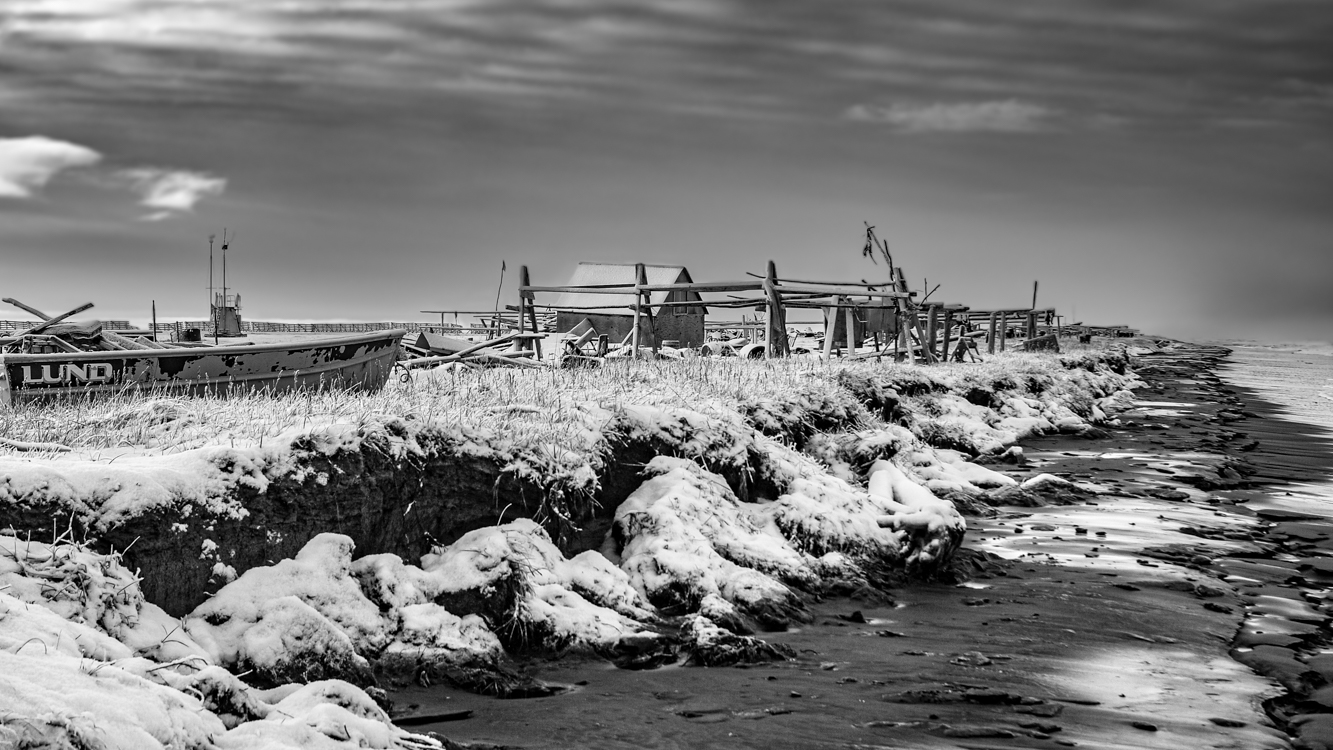
This camp along the shore of the Chukchi Sea almost looks like an ocean going vessel, the cabin itself the wheelhouse, a flag marking the vessel’s bow as it faces a fall sea. Snow but no ice, you can see how the ravenous ocean eats at the shoreline of tiny Sarichef Island. All this will be gone one day… perhaps in not so many years. October 31, 2010
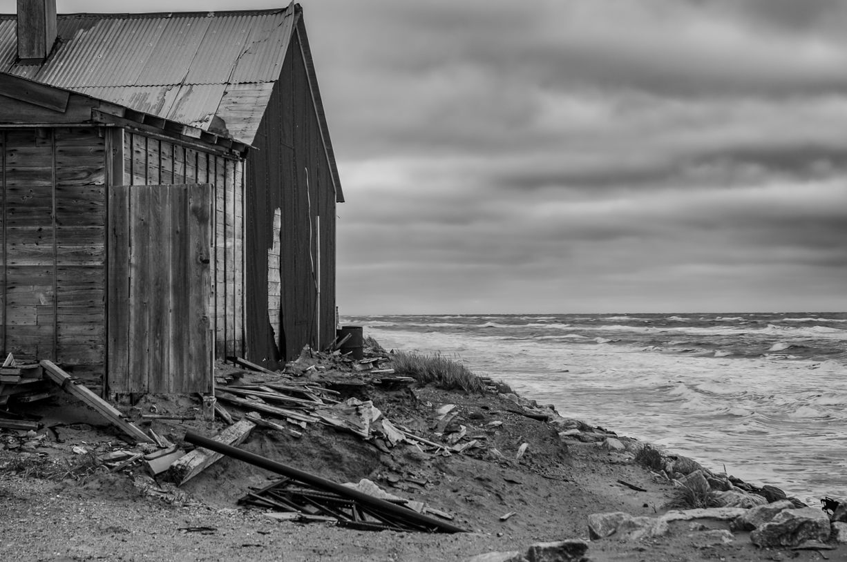
An abandoned home in Shishmaref faces an encroaching sea.
It is reported that since 1969, the ocean has eaten away 200 feet of land along the coast of already tiny Sarichef Island where Shishmaref is located. In the past, a sheet of ice forming in fall and lasting through spring kept the Chukchi sea blanketed and calm. Warming sea temperatures in the Arctic mean the ocean is freezing later. When fall and winter storms occur, packing winds that have traveled uninterrupted over thousands of miles of open sea, the surf thus generated claws at the barrier island without mercy. Particularly violent storms can rip away massive chunks of land. Entire homes have been washed away, a fate this abandoned house appears to be facing. Photograph: October 10, 2010
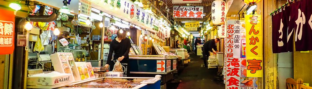
To imagine Shishmaref, begin with Sarichef Island where the village is situated. Sarichef is one of several low-lying barrier islands running for about 70 miles along the northwest shore of Alaska’s Seward Peninsula. If you’ve ever been to North Carolina’s Outer Banks, you have some idea of such islands. Sand is everywhere. The above photo depicts a section of the main thoroughfare traversing this village of about 570 residents. There are no roads connecting Shishmaref with the larger world. Vehicles and building materials arrive primarily by ocean barge. Groceries are freighted in by plane. Because of the added freight costs, everything in the small local store is quite expensive. Pink salmon and Dolly Varden Char which migrate along the beach, seals taken from the nearby sea, and Musk Oxen, Caribou, an occasional Moose and waterfowl along with blueberries and Cloudberries taken from the mainland supplement most diets.
In 2010-2011 when we lived there, virtually the entire community was without the kind of city plumbing considered necessary in most of North America. The white plastic container near the middle of the street is where “honey buckets” are emptied into. These containers are then taken to a settling lagoon. Most houses have large water tanks of up to about 300 gallons which must regularly be refilled. The closest village is Wales, population about 145, over 70 roadless miles down the coast.
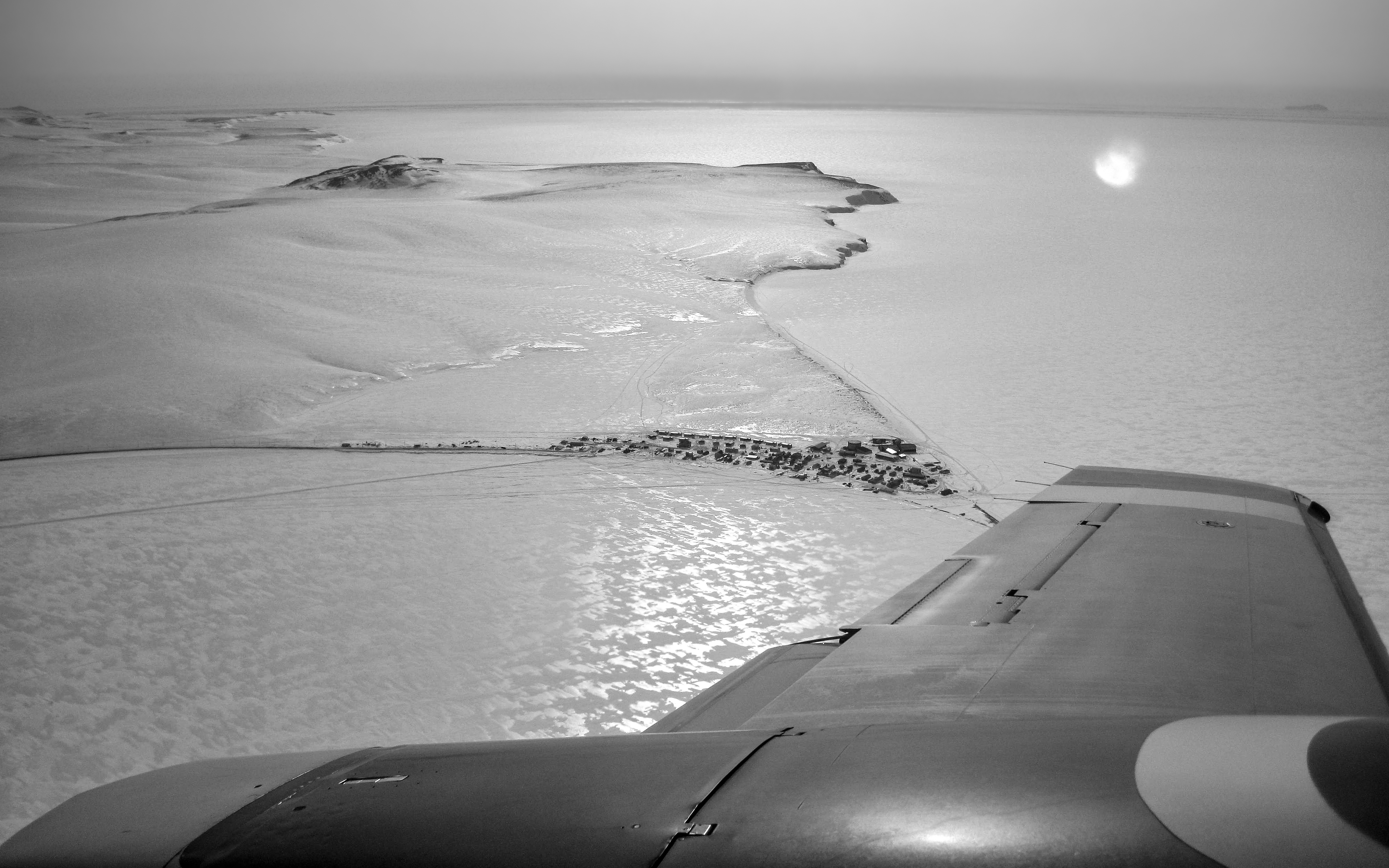
Flying into the village of Shishmaref for the first time was an unforgettable thrill. This wintertime photograph, in which the barrier island upon which Shishmaref is located appears to be connected to land, belies the village’s isolation. That is ice, not terra firma, surrounding Sarichef Island which encompasses only 2.8 square miles and rises no higher than 13 feet above the surrounding sea. The village itself is home to fewer than 600 mostly Inupiat residents. Tucked up against the ever encroaching Chukchi Sea, Shishmaref lies a mere 20 miles below the Arctic Circle, 105 miles from the Siberian coastline across the Bering Strait, 601 miles from Anchorage and 2,939 miles from L.A. The wintertime winds, with a fetch of perhaps thousands of miles across frozen northern seas, blew at times with terrifying ferocity and cold, on one memorable occasion all but burying the village in snow.
In the next few photos to come, I will try to show a bit about life in this remote village which is perhaps best known as being on the vanguard of the impacts of climate warming, but where also there is beautifully crafted artwork and a spirit of resilience. As always, your comments are welcome.
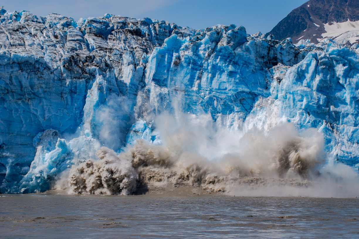
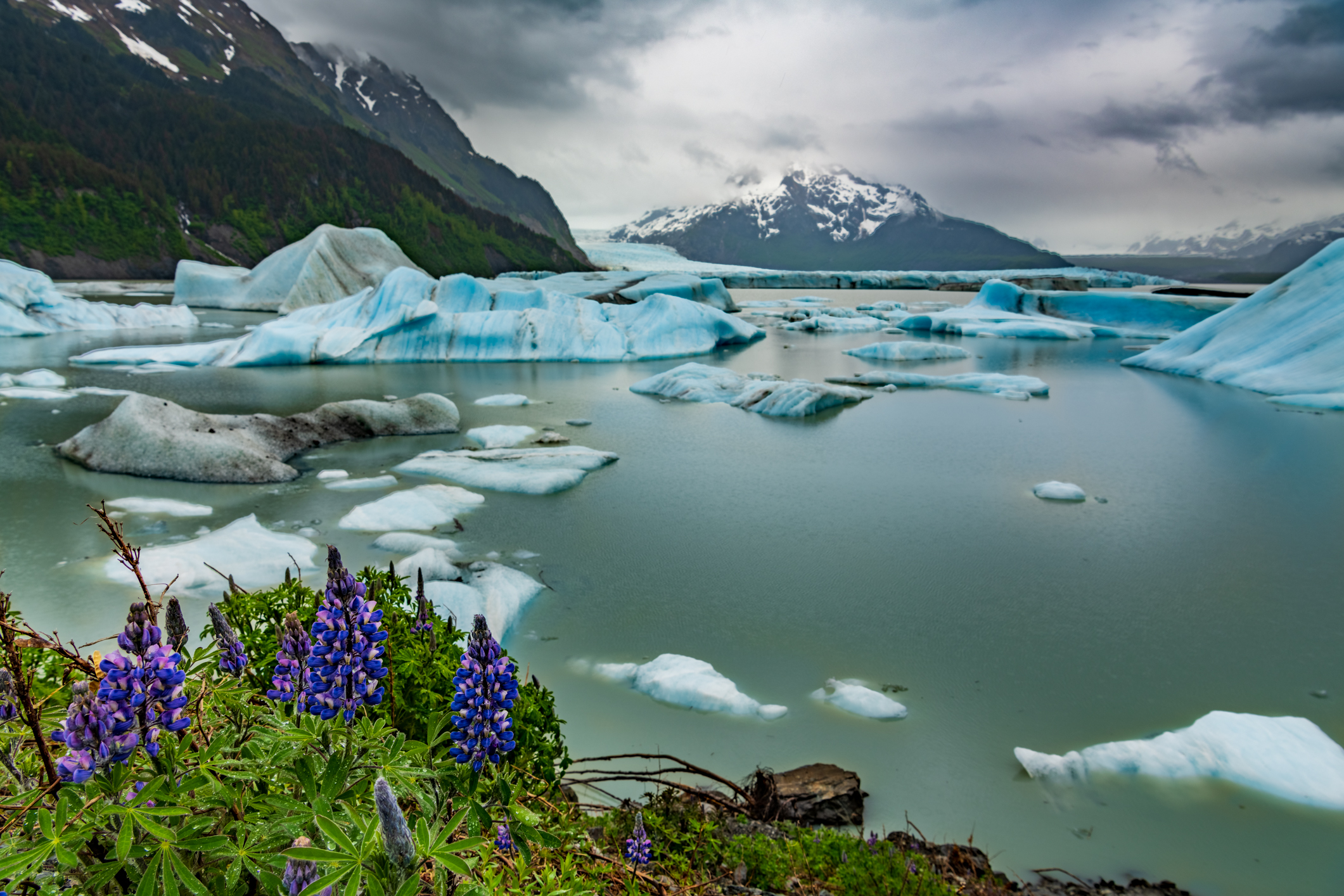
When we first came to Alaska back in 2009, you could still make the 49 mile drive from Cordova to the Million Dollar Bridge (the Bridge to Nowhere). Across the broad, swift, roily Copper River, massive Childs Glacier towered. We had just completed the Salmon Jam half-marathon. Along with another couple, we rented a car and made the drive out through the vast delta wetlands along a mostly unpaved rough, pot-holed road – Trumpeter Swans, other waterfowl, beaver lodges, bear scat and even a couple of moose along the way, distant mountains, our eyes wide with Alaska wow.
Barbra was our primary photographer in those days. We had identified an area that was active, popping and cracking, sloughing off showers of ice. “That entire face is going to go,” I predicted. Barbra set up the camera on a tripod and programmed it to take a shot every second. (The result was like a stop action film.) Shortly after the above shot was made, a wave of five or six feet came barreling toward us with a speed that caught us off guard. I grabbed the tripod as we scrambled for higher ground. Back in Cordova, upon seeing the photos on our camera a Forest Service Ranger told us we had witnessed a “once in every five years or so event.”
Light and creamy vanilla cheesecake drizzled flooded with wineberry syrup. Just building the anticipation for berry-picking season.
For most, I imagine spring flowers sow hope for warmer weather and start dreams of sunny summer adventures. The flowers of this particular spring were different for me.
For the last two summers, Jack and I have spent countless hours studying and identifying all the flowers we could find in the surrounding areas of Chignik Lake. It was a beautiful education. The flowering season began with chocolate lilies and ended with tiny white yarrow with lilac-colored geranium sustaining throughout. Along the growing months from May through October, a rainbow of blossoming gems ebbed and flowed. Although I loved seeing and identifying all the blooms, the flowers that gave me the most joy were the ones that I knew would transform into fruit. As we hiked through the months, I would monitor the progress of my miniature crops as they turned from tiny bud to flower to hard little fruit, and then to the final stage of delectable berry treasures that were ready to harvest.
Whenever Jack and I visit different places, we regularly look for flowers. It is interesting to us to see which flowers we have learned about at the Lake which also grow in other places. As it turns out, we are now in a new place. Yes, a surprising plot twist.
We would not have guessed we were going to make a move…even as late as this recent February. A principal job was opening at my school and I was just about finished with my credentialing coursework. We loved our community and our home. We have close friends and a deep connection to Chignik Lake. But life happens. Way leads to way. Turned out the way that opened was a door we had been keeping an eye on for a long time.
If you’ve been following our story for a long while (like thirteen years long), you’ll remember that our whole Alaska adventure began with a summer-long trip. It was one of those once-in-a-lifetime trips that people do. A hobby at that time had been running destination half marathons. Jack found an interesting destination that would align this hobby with a blend of other interests like road-tripping, camping, boating, and of course visiting Alaska. With just six days to make it up the Al-Can, launching our trusty C-Dory in Valdez, and boating over to the destination Salmon Jam Half Marathon in Cordova Alaska, we would start a journey that we had no idea would change our life. On the way home from that Epic Alaska Summer Adventure, we decided that Alaska would become home. In the way life sometimes circles and spirals, we find ourselves back in Cordova. This time, it is not a travel destination, but a new home.
A common thread in all of our our Alaskan homes has been the opportunity to forage for interesting edible plants. How fortunate are we to live in a big beautiful state that offers so many wild foods…among my all-time favorites – berries! We discovered many flowers on our initial hikes on the trails in the Chugach National Forest. I’m happy to report blueberry, low bush and high bush cranberry, salmonberry, currant, nagoonberry and lots of strawberry flowers. Now, in this new place, I get to follow my familiar summertime tradition of monitoring all of these flowers’ progress from bud to fruit. With any luck, we’ll find lots to harvest later this summer.
Jack suggested I share my process for making wineberry (aka nagoonberry) syrup. Most people find the process to be tedious. It’s pretty simple, actually. After picking the precious gems from your secret spot, take them home and xxxxxxx xxxxxxx xxxxxxxxxx xxxxxxx xxxxxxx xxxxx xxxxxxxx xxxxxx. For each cup of processed berries add 1/4 cup of water. Simmer the berries until soft. Smash the mixture with a potato masher. Separate the juice from the pulp by suspending a cheesecloth over a . Every time I try to publish this, it gets redacted. I guess the FBI doesn’t want it shared – (Fruit and Berry Interagency). 😉
For this creation, I used a no-bake cheesecake recipe adapted from a blog I follow, Sally’s Baking Addiction. I modified it to make a 4-inch version, which is perfect for two hungry writers, or can be served to four for a nice little sweet bite at the end of a meal. I like the no-bake version to complement fruit syrups because it is light and airy but still retains the tanginess of the flavor you’d expect from a cheesecake.
4-inch No Bake Cheesecake
Ingredients
Crust
1/2 cup graham cracker crumbs
1.5 tbsp brown sugar
3 tbsp unsalted butter, melted
Cheesecake
1/4 cup + 1 tbsp heavy whipping cream
6 oz. cream cheese, room temp
2 tbsp granulated sugar
1/2 tbsp powdered sugar
1 tbsp sour cream
1/2 tsp lemon juice
1/2 tsp pure vanilla extract
Directions
To make the crust, stir together crust ingredients. Pour into a 4-inch springform pan. Use the back of a spoon to pack the crust tightly against the bottom and sides of the pan. Place pan in freezer while the filling is being made.
Using an electric mixer fitted with a whisk attachment, whisk heavy cream until stiff peaks are formed. Scrape whipped cream into a separate bowl.
Using the original bowl you used for whipping cream, beat cream cheese and granulated sugar together until smooth.
Add powdered sugar, sour cream, lemon and vanilla. Beat again until mixture is smooth.
Gently fold whipped cream into cream cheese mixture.
Spread cheesecake filling into prepared crust.
Cover with plastic wrap and let cheesecake chill and set. I left it in the fridge for about 18 hours.
When ready to serve, loosen the chilled cheesecake by running a knife around the perimeter of the pan before springing it open. I prefer to serve the cheesecake without any syrup and let my guests adorn their own. It definitely adds to the anticipation and the wow factor.
This is what a sub-polar temperate rainforest looks like on the dry side of a mountain. The first part of the trail gently meanders through a forest of hemlock, spruce and cedar. The understory is populated by blueberry, currant, salmonberry, devil’s club, twisted stalk, several species of fern and other plants.
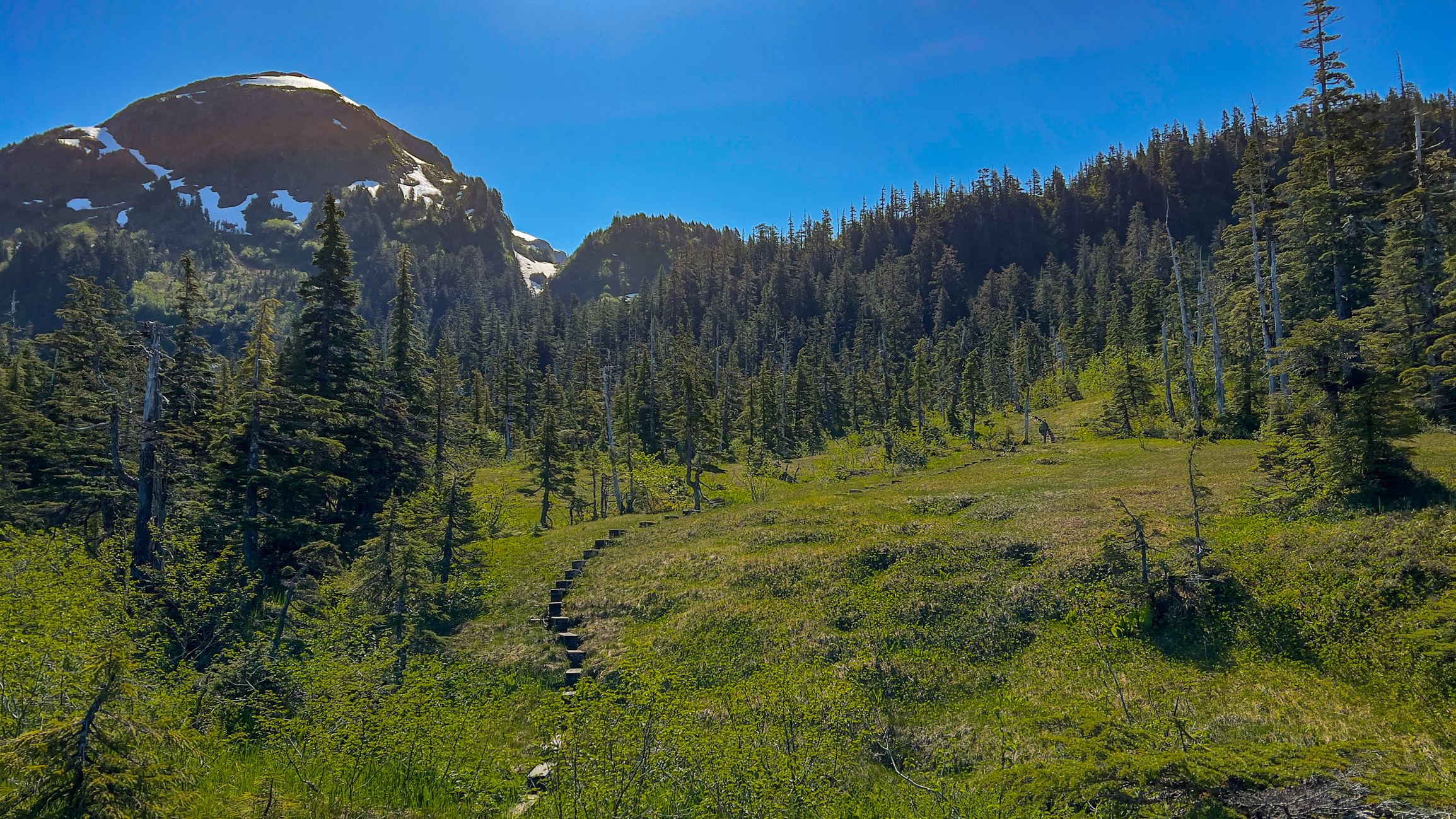
On June 18 we took advantage of a warm day filled with sunshine to take on the Heney Ridge Trail near Cordova. Lingering snow fields above the tree line stopped us with about a quarter mile to go on this 4.1 mile trail, but from where we stopped, the sweeping views taking in snow-capped peaks and Prince William Sound were nonetheless spectacular.
As we gained elevation, the trees gradually thinned out and in places gave way to muskeg meadows. This is marshy, fragile terrain. Narrow boardwalks and steps installed by the Forest Service help minimize hikers’ impact. (Barbra is right of center – a tiny figure giving some idea of the scale of this landscape.
Getting even a glimpse of birds proved challenging, but along the way we heard the songs and chatterings of Boreal Chickadees, Golden-crowned Kinglets, Ruby-crowned Kinglets, Orange-crowned Warblers, Wilson’s Warblers, Hermit Thrushes, Varied Thrushes, American Robins, Crows and Ravens. An American Dipper buzzed by as we were admiring the upper reaches of Heney Creek, and once we had climbed above the tree line we were able to look down on soaring eagles and gulls. Fresh bear scat. Fox scat dense with hair from its meal.
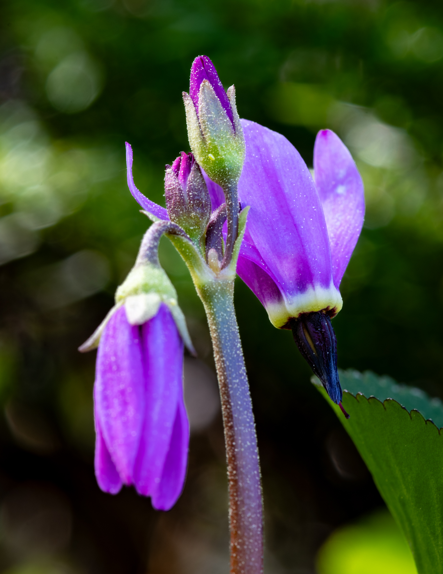
It was in these high meadows that we came upon an old friend: Shooting Stars, a favorite flower we didn’t have at Chignik Lake and were happy to reacquaint. This specimen is dusted with pollen from evergreen trees.
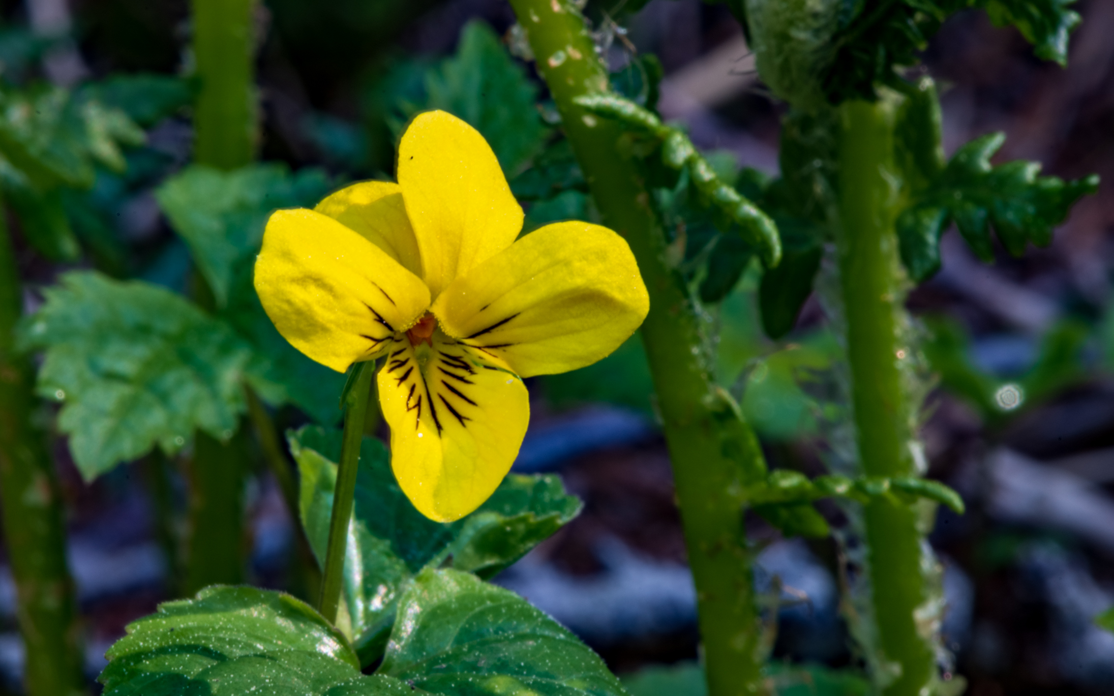
Several types of violet are native to Alaska. This tiny beauty is Stream Violet which we found growing near seeps and streams along the trail.
From approximately the halfway point, the trail became steep (there is a ladder in one place) and mostly rocky. No technical climbing involved, but Barbra and I agreed on the adjective “rigorous.” Totally worth the effort, though.
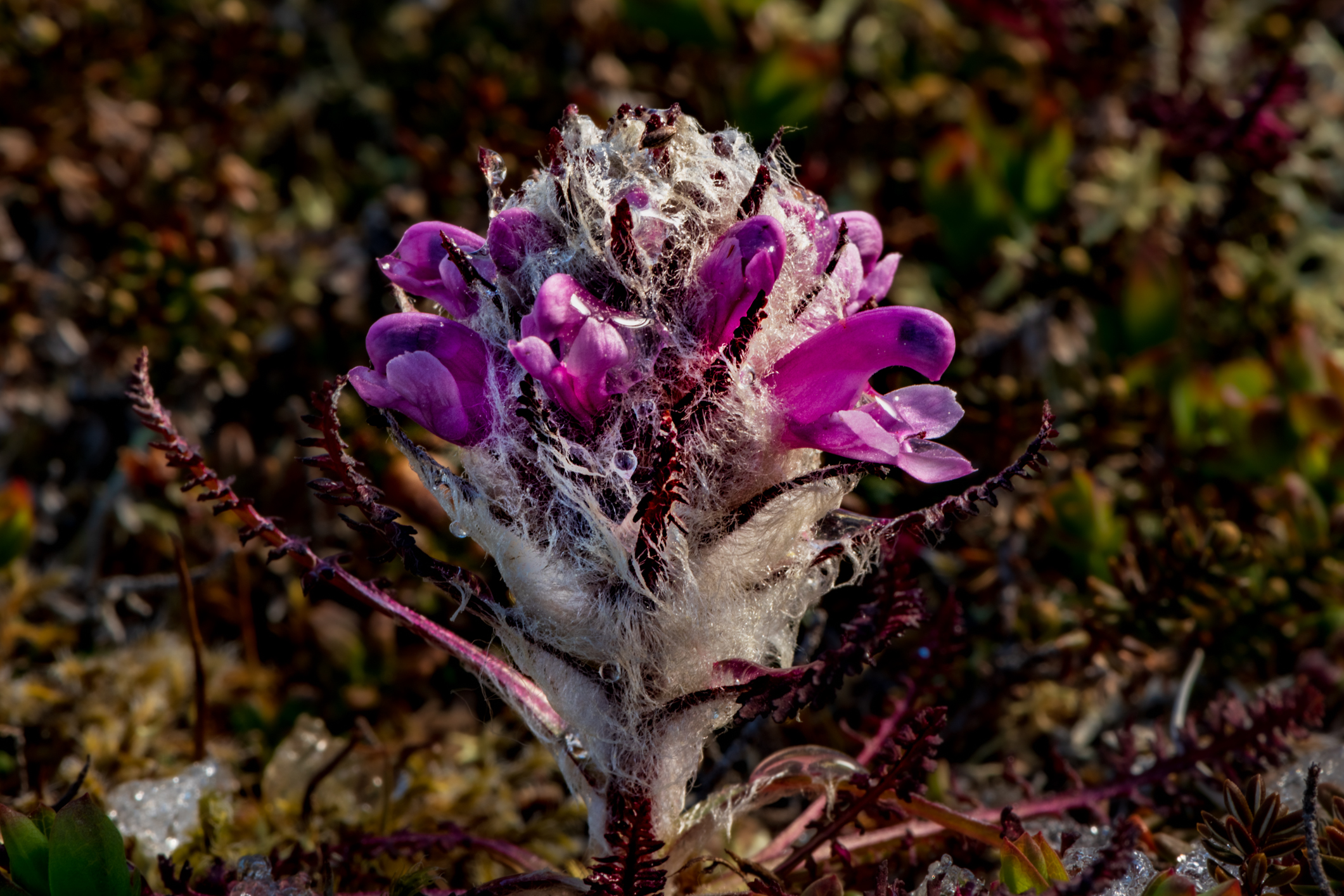
At the rocky terminus of our hike, we looked for alpine flowers. Small but beautiful, we found a few. Jewel of the mountains, Wooly Lousewort.
Narcissus-flowered Anemone
One often has to look closely to find the gems that are alpine flowers. This Wedge-leafed Primrose bloom is about the size of a fingernail…
…and these Alaskan Pincushion flowers are even small than that. But they’re all favorites, the two of us calling back and forth to each other with each discovery. Bell heather, tiny Vaccinium, minuscule Alpine Azalea, White Marsh Marigold (which might better be named Snow Marigold) in wet places…
Rock cairns mark the alpine portion of the trail. The last part is fairly lightly traveled, and it’s easy to confuse a rocky ephemeral creek bed for the actual path. Eagles soaring below, piping from perches in the distant forest, waterfalls rushing from melting snowfields, a light breeze, shirtsleeve warm, quiet… We’ll be back.
I found a jar upon a mountain and thought to open it it smelled of moonshine and spring winds upon that mountain top It gathered in the village below the lake and river and distant sea
I found a jar upon a mountain near the village where I lived it caught the light a certain way and seemed to hold it there It gathered in the autumn day the sky, the mountains, the distant sea
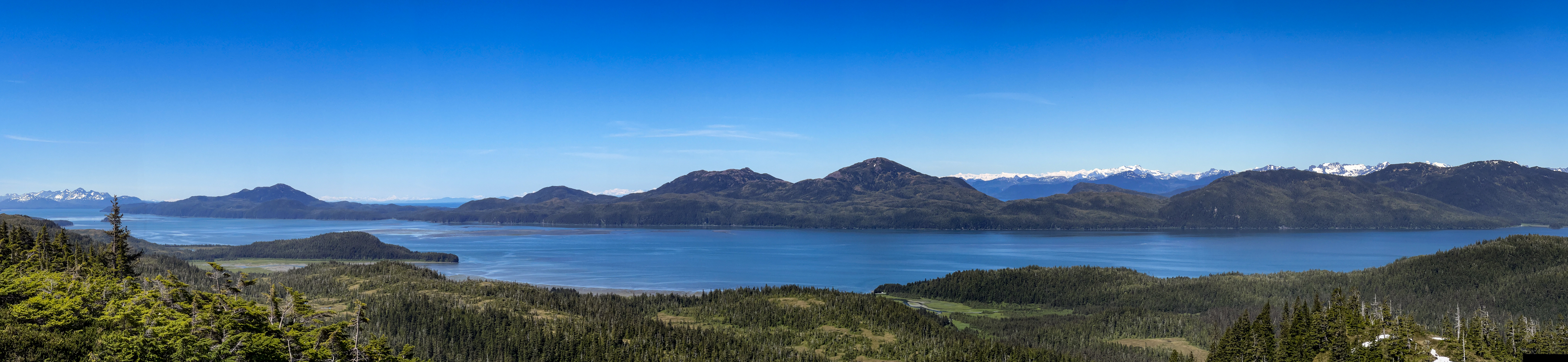
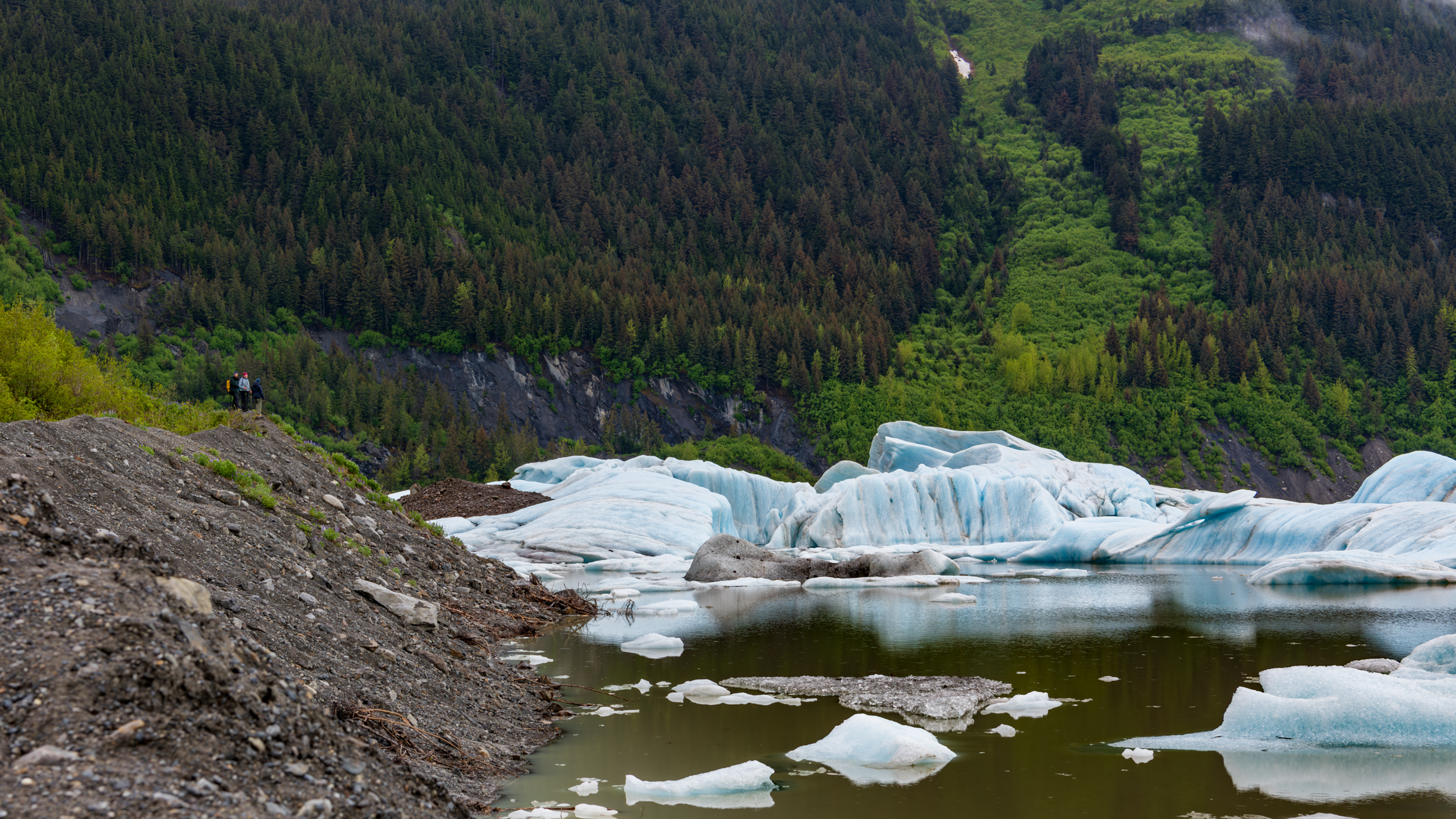
Quite a few of the images I capture are key-worded “vast” in my Lightroom catalog. Here, as I was walking along the glacial moraine at Sheridan Lake, I turned around just in time to catch Barbra and two visiting friends taking in the landscape. Located about 17 miles from our home in Cordova, a short walk through spruce and hemlock forests leads to this magical lake where, in wintertime people ice skate among massive structures of ice and in springtime and early summer kayak and canoe through the same setting.
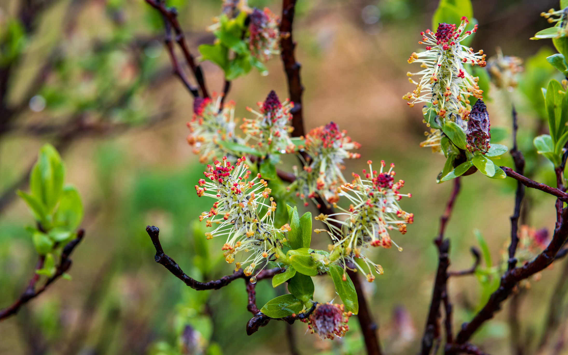
It was June 12 when we visited the lake, but here on the edge of Alaska’s Chugach National Forest, the world’s northernmost rainforest, it’s still spring as these willow flowers attest.
That’s Sheridan Mountain on the left side of this image – another hike for another day. Just right of center is a peek view of Sheridan Glacier itself.
We’re hoping to visit this lake again soon with our pack rafts, hopefully on a day with a little nicer light. It’d be interesting to get a closer view of the ice, and to put a watercraft of known size in the picture to provide a sense of scale.
Having arrived in Cordova by ferry from Whittier (a 100-mile cruise across Prince William Sound) on May 15, although most of our time has been given to setting up our new home, we’ve already managed to feather in a handful of hikes. With nearly 20 named Forest Service trails within a short drive – and all of them changing with the seasons, all of them beautiful as they wind through stands of moss-draped evergreens, through muskeg, up mountains and along lakes, rivers and streams, there will be lots more to come. So stay tuned!
A landscape seen by fewer than 100 living people….
The Hike Up Flattop
There’s a small mountain behind our village. We call it Flattop, though once you reach the peak you find that it is somewhat rounded. Although reaching the summit constitutes an elevation gain of only about 1,200 feet (a quarter of a mile; four football fields), because it is the foreword-most mountain facing the village, the summit provides an unobstructed 180 degree view sweeping from the corner of Chignik Lake to one’s left where Clarks River enters, down the lake and through the village, and then down the Chignik River all the way across the estuary to the next village, Chignik Lagoon, a vista encompassing about 12 miles. But in fact, the view is more grand even than that, for one can see mountains 20 miles beyond Chignik Lagoon where a portion of the Alaska Peninsula curves out into the Alaska Gulf, and while gazing across Chignik Lake the landscape disappears in haze over Bristol Bay. Keeping in mind that a few steps beyond the last house in the village one is entering a landscape fewer than 100 living people have seen, the view from Flattop is even more exclusive.
The roundtrip hike from our home to the summit and back is fairly rigorous. We begin by following the community’s main thoroughfare, a dirt road that curves along the lakeshore, crosses a small, willow-crowded stream inhabited by char, and then branches off to the left past a few houses beyond which is a honda trail. For about two miles, the trail alternately cuts through stands of scrub alder and willow, open tundra, and shoulder-high grasses, fireweed, ferns and salmonberry brakes.
The trailhead leading up Flattop is easy to miss if you don’t know where to look. People – young men who are hard on their machines – very occasionally take their quads up the mountain, though scarcely often enough to beat back the jungle-thick vegetation waiting to reclaim any seldom-used path in this part of the world. Not long ago, a neighbor was lucky to get clear in time to avoid injury when the mountain took control of his honda. His quad is now somewhere on Flattop’s steep flanks, hung up in alders, unrecoverable. One’s own two feet are the more prudent – and satisfying – option for ascent.
In the early morning of September 17, we entered the trailhead through a field of tall grasses and fireweed gone to downy seed, colored with autumn, made dripping wet with low fog. As we gained elevation, the grasses, ferns and flower stalks gave way to thick stands of salmonberry bushes. It wasn’t long before our pants were soaked and our water-resistant boots were saturated through to squishy socks. Sunshine in the forecast promised dry clothing once we climbed beyond the vegetation.
Landmark by landmark, salmonberry brakes began to thin. Alders grew smaller and more wind-twisted. We ambled through openings where, back in early June, we’d come across patches of heathers and wildflowers – vaccinium, geranium, yarrow, paintbrush, candle orchid, fireweed. At times we lost the faint trail, the path buried in tall, thick grasses or barely discernible through tangled tunnels of gnarled alders. Just as the sun broke free from mist and crested the summit we emerged onto the first treeless scree, the sudden warmth and open landscape a joy, handfuls of lingonberries, tart, sweet, energizing.
As we continued up the slope, I studied the loose scree for signs of the Weasel Snout, lousewort, Alpine Azalea, Alp Lily, Pincushion, Moss Campion, Roseroot, avens, saxifrage and Purple Oxytrope I’d photographed in June, but aside from a few lupine still clinging to periwinkle-colored blooms, the rest were gone, the few remaining leaves various hues of yellow, red and orange. Near the top we were surprised to find blueberries, wind-stunted bushes hugging thin soil, leaves crimson, berries big and frost-nipped sweet.
We had chosen a day when the forecast predicted calm air, offering the hope of mountains mirrored in a glassy lake and pleasant loafing at the top. We scanned the lakeshore and flats for moose and other wildlife, but aside from a few Black-capped Chickadees, Pine Grosbeaks, a sparrow or three and clouds of midges dancing in filtered sunlight, animals were scarce, though near the summit my spirit bird, a Northern Shrike, materialized from out of nowhere to hover a few feet above my head in order to puzzle me out. Bear tracks all the way at the top. Moose tracks and fox tracks along the way. Lynx scat… maybe.
The video is best viewed on a large screen. As you watch, notice the round, snow-crowned summit just barely peaking out from behind foreground mountains in the view across the lake. That’s Mount Veniaminof, an occasionally active volcano 24 miles southwest of Chignik Lake. The earth’s curve over that distance causes it to appear to be only as tall as the closer 3,000 foot peaks. But in fact, Veniaminof touches the sky at 8,225 feet. We hear it rumble from time to time and have occasionally woken to a smoke-clouded sky or a fine dusting of volcanic ash on new snow in the village.
The corner of the lake to the left, in front of those mountains, is where Clarks River debouches. A major salmon spawning tributary, in September Clarks offers spectacular, nearly untouched fly-fishing for returning Coho Salmon.
Then, looking up the lake through the gap in the hills and mountains, the landscape disappears into haze. Black River flows into Chignik Lake here, beyond which is miles of Black River itself, and then the upper lake, Black Lake. Past that is a vast area of boggy tundra and kettle ponds all the way across the peninsula to the ghost village of Ilnik and the coast where sandy barrier islands, The Seal Islands, front Bristol Bay.
Following the landscape to the right, the lake narrows as it flows past the village of Chignik Lake, a community of about 50 to 55 people, most of whom are of Alutiiq heritage. The large white buildings in the middle are the school gym (left) and the school itself (right) where Barbra teaches. Just as the village ends, the lake narrows further, picks up speed and becomes Chignik River. A narrow dirt road follows the river downstream and terminates at a boat landing across from the fish-counting weir, the buildings of which are just barely visible. There are no roads beyond this one, which terminates on its other end at the airfield.
I included a photograph looking downriver and across the estuary, locally referred to as the lagoon. The image zooms in on the village of Chignik Lagoon, the community closest to Chignik Lake. With no roads nor even trails linking the communities, the river and estuary serve as the highway. Virtually everyone in The Chigniks owns a skiff or two.
The end credits roll over a black and white photograph I made from Flattop’s summit in early June.
Hiking with us on this day were school faculty members new to The Lake: Melody Wiggins, Jacob Chapman and Melody’s son, Micah. Barbra is on the right in the group photo.