
Whaling Festival Site, Point Hope, Alaska. The larger bones presented as arches are the jawbones of Bowhead Whales. Traditionally, the skull is returned to the sea so that the whale’s spirit is properly released. Point Hope, Alaska, August 12, 2012

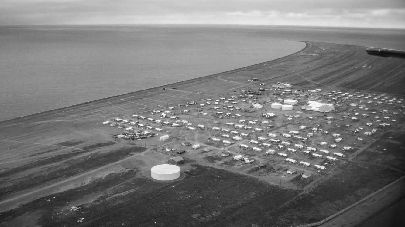
Modern-day Point Hope is located on a narrow peninsula hooking into the Chukchi Sea. In the not-so-distant past, the village was further out on the peninsula, but erosion caused by an encroaching sea has wiped away a good bit of the peninsula, and the old village, called Tikigaq (which means index finger – for the peninsula’s shape), was relocated further inland due to seawater inundation. With evidence of habitation going back at least nine thousand years, Tikigaq Peninsula is regarded as one of the very oldest continuously inhabited sites in North America.
The very essence of an Alaskan bush village is its isolation and remoteness. The only road leading out of Point Hope, Seven Mile Road, ends abruptly a good bit less then seven miles: 250 miles from Barrow, 572 miles to Fairbanks, 694 miles from Anchorage. Thus Point Hope exists as a neatly lain out grid of homes and other buildings surrounded on two sides by water and on one by the vast Arctic tundra. Polar Bears and Arctic Foxes are regular visitors. To experience life in a place so thoroughly separated from the rest of the world is perspective changing – and in an unexpected way, exhilarating.
Large ocean-going barges freight in everything from the school bus – which keeps children safe from both frostbite and Polar Bears – to heavy equipment and building supplies; planes bring in smaller items, including groceries and mail. Hunting and gathering provide a great deal of additional food. This subsistence take includes Bowhead and Beluga whale meat and blubber, caribou, ducks, geese, ptarmigan, salmon, char and grayling along with cloudberries (Rubus chamaemorus) a few blueberries and in some families, seaweeds.
Photographs in coming days will show more of the village and perhaps lend some insight into life there. Thanks for reading.

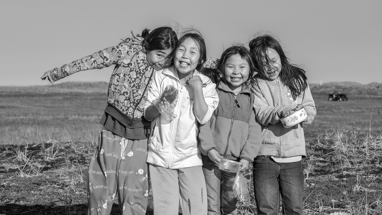
As is the case anywhere one might go, there are multiple realities in Shishmaref – or in any bush village. Some of these realities fit together neatly in a positive and even happy manner, like smiling faces after berry picking on a pleasantly crisp fall morning. Some realities exist more as collective memories, and you’d have to dig and observe closely to find their vestiges. Other realities contradict and clash and it can be difficult to understand how they are connected to the broader cultural, and still other realities go mostly undiscussed – pretended away – as they seep into village fabric like a sludgy toxin.
A reality in the “sludgy toxin” category in most bush communities we are familiar with are the schools. For anyone who was fortunate enough to be educated in a fairly decent k-12 system, or who has taught in such schools, the level of professional misfeasance and malfeasance – the combination of indifference, incompetence and outright corruption in Alaska’s bush schools – would probably defy belief. Before coming to Alaska, Barbra and I taught in good schools in the lower 48. So we know what that looks like. Nothing in that experience prepared us for what we encountered in the Alaskan Bush. The blame, when one talks to many teachers and administrators in bush Alaska, is placed on the children themselves and their parents. These educators and administrators spin their tales to state legislators, the governor’s office, department of education officials, university education departments and anyone else who asks, and Alaska’s state legislators, the governor’s office, department of education officials and university personnel nod along, agreeing that little can be done to improve matters.
But the reality is that any of the schools we taught in, visited or heard about from others could have easily… and I emphasize easily… been improved with a bit of competent administration. The acquiescence to self-serving fictions among Alaska’s leadership – the phony wistful sighs followed by reassurances among themselves that the problems can’t be fixed, so therefore they aren’t obliged to try – continues year after year.
Because it is easy to dismiss these bush schools and the Native communities they serve. After all, these are other people’s children.
Thank you for allowing me to finally get that off my chest. Comments, as always, are welcome. JD

* “Honda” is the Alaskan term for quad or ATV. “Snowmachine” is Alaskan for snowmobile. Out in the bush, bicycles are often called pedal bikes to distinguish them from hondas/ATVs, which are also often called bikes.
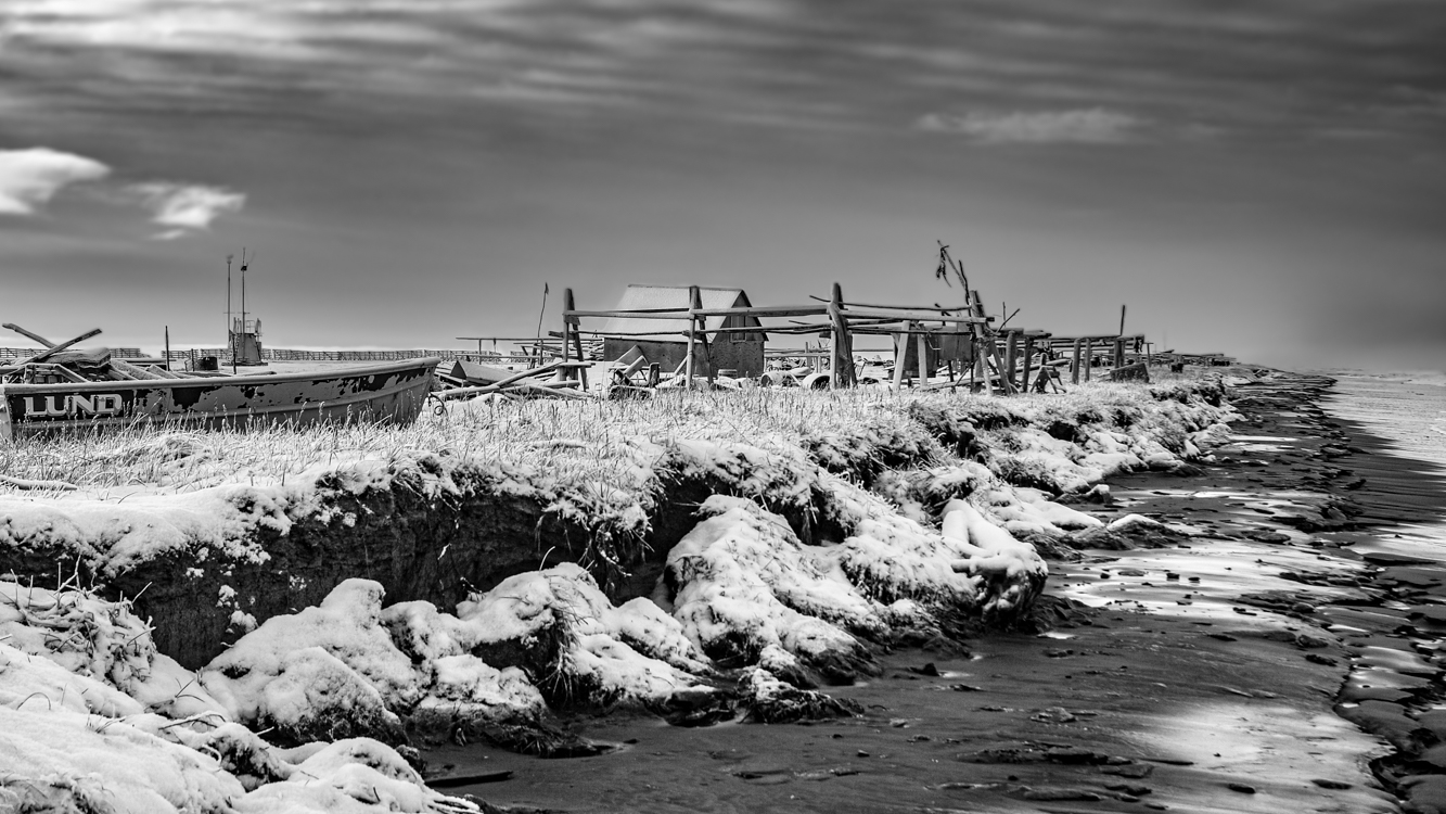
This camp along the shore of the Chukchi Sea almost looks like an ocean going vessel, the cabin itself the wheelhouse, a flag marking the vessel’s bow as it faces a fall sea. Snow but no ice, you can see how the ravenous ocean eats at the shoreline of tiny Sarichef Island. All this will be gone one day… perhaps in not so many years. October 31, 2010
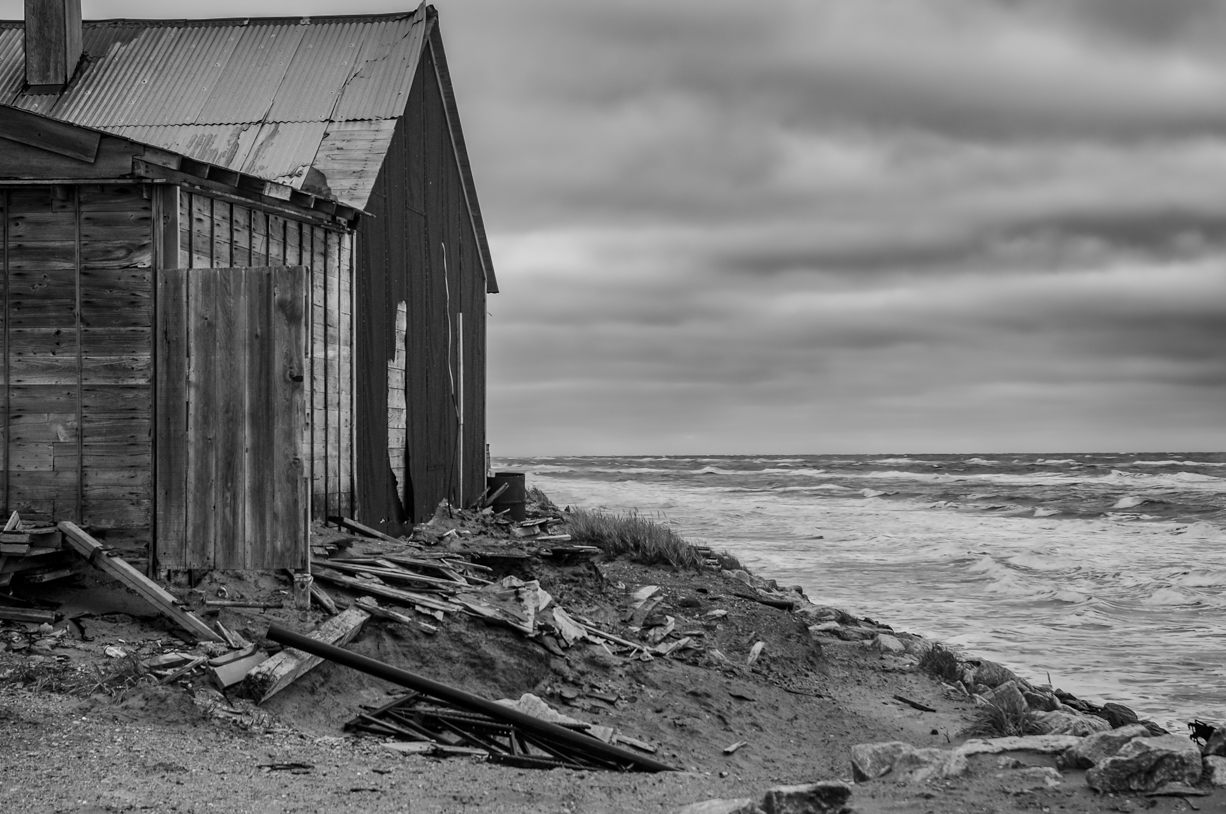
It is reported that since 1969, the ocean has eaten away 200 feet of land along the coast of already tiny Sarichef Island where Shishmaref is located. In the past, a sheet of ice forming in fall and lasting through spring kept the Chukchi sea blanketed and calm. Warming sea temperatures in the Arctic mean the ocean is freezing later. When fall and winter storms occur, packing winds that have traveled uninterrupted over thousands of miles of open sea, the surf thus generated claws at the barrier island without mercy. Particularly violent storms can rip away massive chunks of land. Entire homes have been washed away, a fate this abandoned house appears to be facing. Photograph: October 10, 2010

To imagine Shishmaref, begin with Sarichef Island where the village is situated. Sarichef is one of several low-lying barrier islands running for about 70 miles along the northwest shore of Alaska’s Seward Peninsula. If you’ve ever been to North Carolina’s Outer Banks, you have some idea of such islands. Sand is everywhere. The above photo depicts a section of the main thoroughfare traversing this village of about 570 residents. There are no roads connecting Shishmaref with the larger world. Vehicles and building materials arrive primarily by ocean barge. Groceries are freighted in by plane. Because of the added freight costs, everything in the small local store is quite expensive. Pink salmon and Dolly Varden Char which migrate along the beach, seals taken from the nearby sea, and Musk Oxen, Caribou, an occasional Moose and waterfowl along with blueberries and Cloudberries taken from the mainland supplement most diets.
In 2010-2011 when we lived there, virtually the entire community was without the kind of city plumbing considered necessary in most of North America. The white plastic container near the middle of the street is where “honey buckets” are emptied into. These containers are then taken to a settling lagoon. Most houses have large water tanks of up to about 300 gallons which must regularly be refilled. The closest village is Wales, population about 145, over 70 roadless miles down the coast.
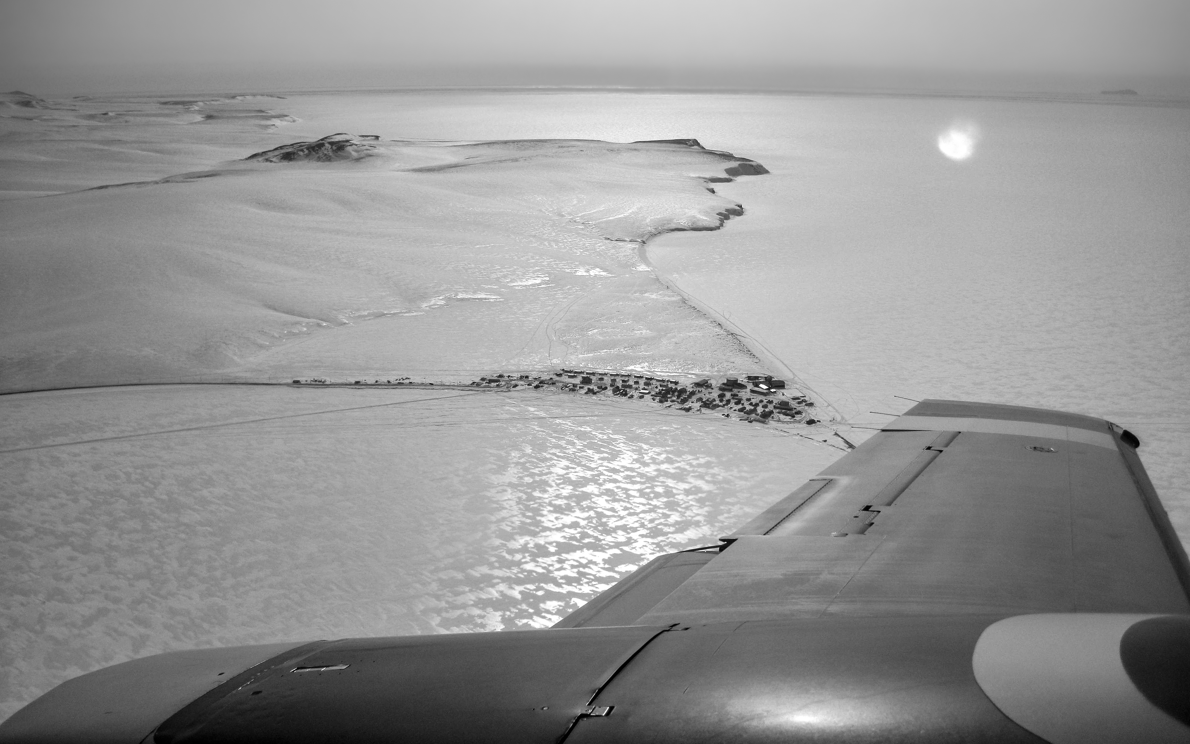
Flying into the village of Shishmaref for the first time was an unforgettable thrill. This wintertime photograph, in which the barrier island upon which Shishmaref is located appears to be connected to land, belies the village’s isolation. That is ice, not terra firma, surrounding Sarichef Island which encompasses only 2.8 square miles and rises no higher than 13 feet above the surrounding sea. The village itself is home to fewer than 600 mostly Inupiat residents. Tucked up against the ever encroaching Chukchi Sea, Shishmaref lies a mere 20 miles below the Arctic Circle, 105 miles from the Siberian coastline across the Bering Strait, 601 miles from Anchorage and 2,939 miles from L.A. The wintertime winds, with a fetch of perhaps thousands of miles across frozen northern seas, blew at times with terrifying ferocity and cold, on one memorable occasion all but burying the village in snow.
In the next few photos to come, I will try to show a bit about life in this remote village which is perhaps best known as being on the vanguard of the impacts of climate warming, but where also there is beautifully crafted artwork and a spirit of resilience. As always, your comments are welcome.
When we first came to Alaska back in 2009, you could still make the 49 mile drive from Cordova to the Million Dollar Bridge (the Bridge to Nowhere). Across the broad, swift, roily Copper River, massive Childs Glacier towered. We had just completed the Salmon Jam half-marathon. Along with another couple, we rented a car and made the drive out through the vast delta wetlands along a mostly unpaved rough, pot-holed road – Trumpeter Swans, other waterfowl, beaver lodges, bear scat and even a couple of moose along the way, distant mountains, our eyes wide with Alaska wow.
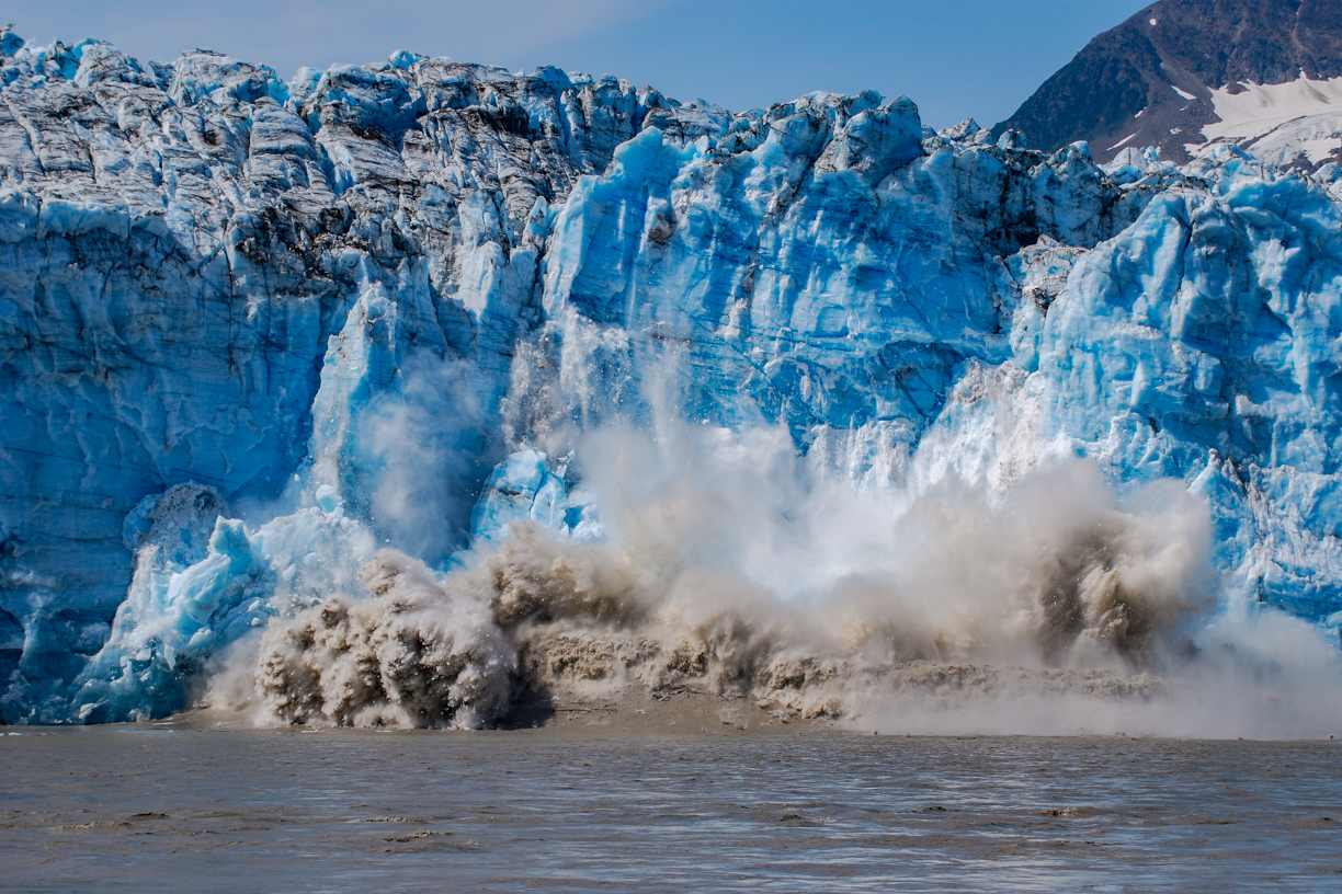
Barbra was our primary photographer in those days. We had identified an area that was active, popping and cracking, sloughing off showers of ice. “That entire face is going to go,” I predicted. Barbra set up the camera on a tripod and programmed it to take a shot every second. (The result was like a stop action film.) Shortly after the above shot was made, a wave of five or six feet came barreling toward us with a speed that caught us off guard. I grabbed the tripod as we scrambled for higher ground. Back in Cordova, upon seeing the photos on our camera a Forest Service Ranger told us we had witnessed a “once in every five years or so event.”
Here is the same shot as a black & white image.

