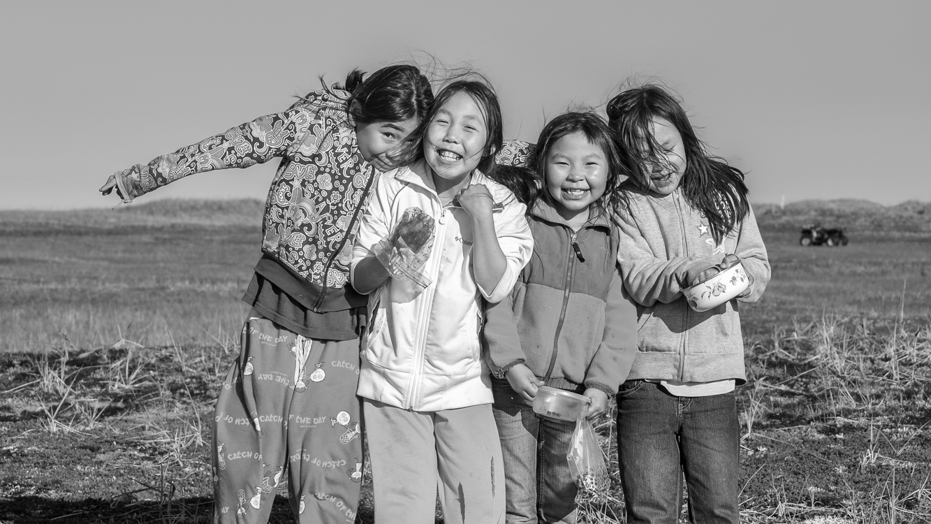
Blueberry picking on the Arctic tundra. This photograph was used in a Ted Talk about Climate Change. Sarichef Island, September, 2010
As is the case anywhere one might go, there are multiple realities in Shishmaref – or in any bush village. Some of these realities fit together neatly in a positive and even happy manner, like smiling faces after berry picking on a pleasantly crisp fall morning. Some realities exist more as collective memories, and you’d have to dig and observe closely to find their vestiges. Other realities contradict and clash and it can be difficult to understand how they are connected to the broader cultural, and still other realities go mostly undiscussed – pretended away – as they seep into village fabric like a sludgy toxin.
A reality in the “sludgy toxin” category in most bush communities we are familiar with are the schools. For anyone who was fortunate enough to be educated in a fairly decent k-12 system, or who has taught in such schools, the level of professional misfeasance and malfeasance – the combination of indifference, incompetence and outright corruption in Alaska’s bush schools – would probably defy belief. Before coming to Alaska, Barbra and I taught in good schools in the lower 48. So we know what that looks like. Nothing in that experience prepared us for what we encountered in the Alaskan Bush. The blame, when one talks to many teachers and administrators in bush Alaska, is placed on the children themselves and their parents. These educators and administrators spin their tales to state legislators, the governor’s office, department of education officials, university education departments and anyone else who asks, and Alaska’s state legislators, the governor’s office, department of education officials and university personnel nod along, agreeing that little can be done to improve matters.
But the reality is that any of the schools we taught in, visited or heard about from others could have easily… and I emphasize easily… been improved with a bit of competent administration. The acquiescence to self-serving fictions among Alaska’s leadership – the phony wistful sighs followed by reassurances among themselves that the problems can’t be fixed, so therefore they aren’t obliged to try – continues year after year.
Because it is easy to dismiss these bush schools and the Native communities they serve. After all, these are other people’s children.
Thank you for allowing me to finally get that off my chest. Comments, as always, are welcome. JD
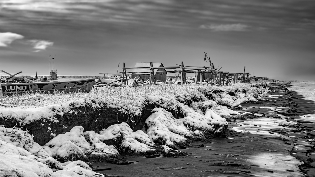
In bush communities such as Shishmaref, virtually everything comes into the village either by plane or by barge. Trucks, boats, hondas*, snowmachines*, pipes, building materials, food, clothing, clothing washers, bags of chips, cases of pop, birthday presents… It’s not practical to ship out empty detergent bottles, worn out dryers, broken down vehicles or broken toys. So most of the refuse goes to a local dump. In these modern times, when most of what is consumed takes a very long time to return to its elemental or mineral form, whatever isn’t burned remains there – buried or piled high. And there it will remain till the sea comes one day. (Photograph by Barbra Donachy, October 31, 2010)
* “Honda” is the Alaskan term for quad or ATV. “Snowmachine” is Alaskan for snowmobile. Out in the bush, bicycles are often called pedal bikes to distinguish them from hondas/ATVs, which are also often called bikes.
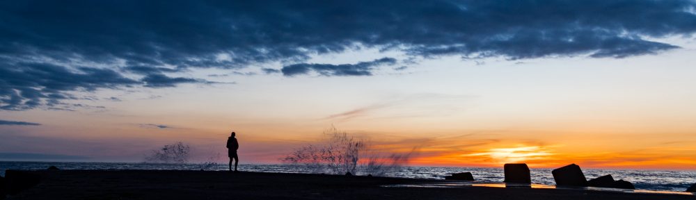
This camp along the shore of the Chukchi Sea almost looks like an ocean going vessel, the cabin itself the wheelhouse, a flag marking the vessel’s bow as it faces a fall sea. Snow but no ice, you can see how the ravenous ocean eats at the shoreline of tiny Sarichef Island. All this will be gone one day… perhaps in not so many years. October 31, 2010
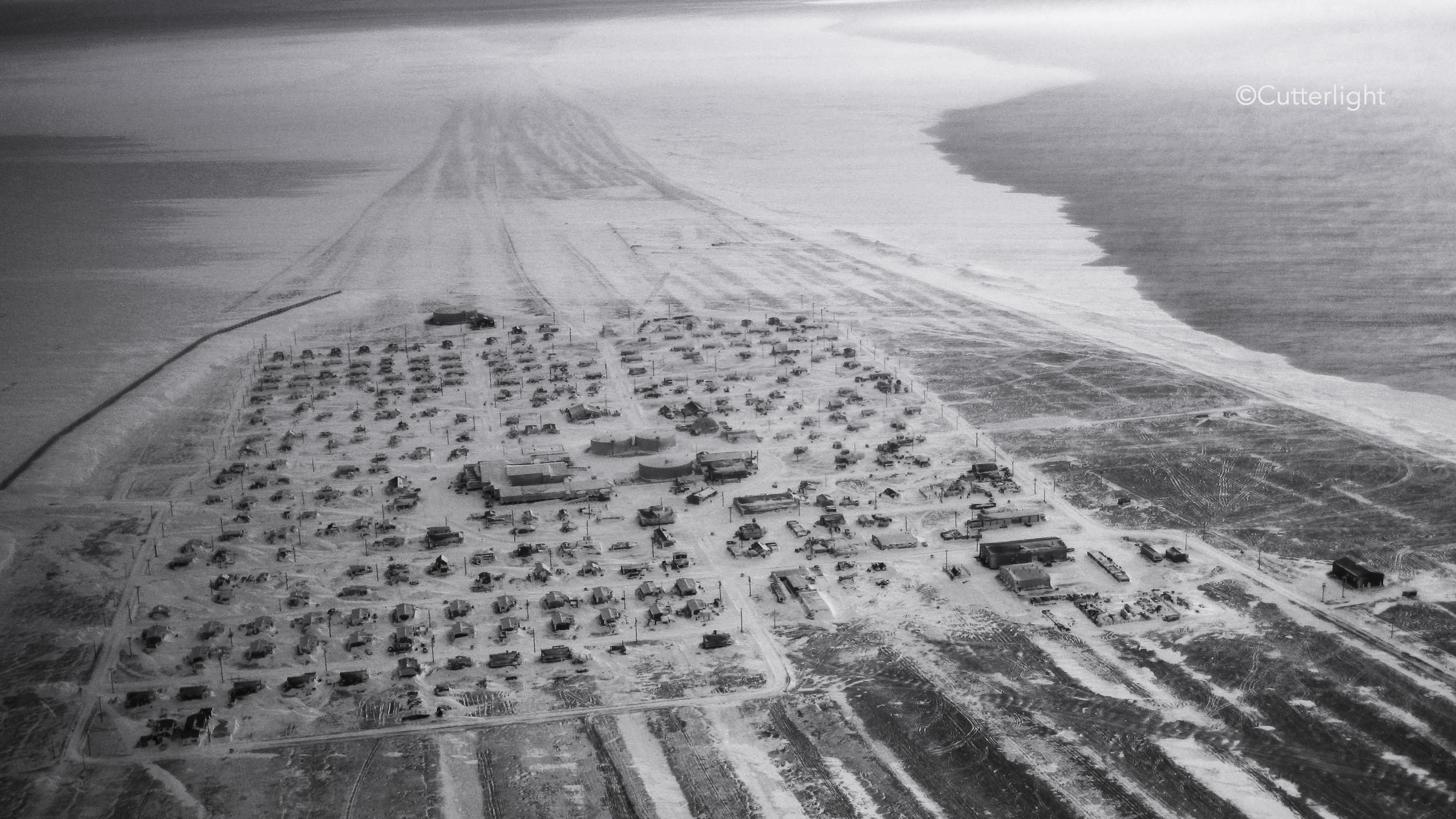
To imagine Shishmaref, begin with Sarichef Island where the village is situated. Sarichef is one of several low-lying barrier islands running for about 70 miles along the northwest shore of Alaska’s Seward Peninsula. If you’ve ever been to North Carolina’s Outer Banks, you have some idea of such islands. Sand is everywhere. The above photo depicts a section of the main thoroughfare traversing this village of about 570 residents. There are no roads connecting Shishmaref with the larger world. Vehicles and building materials arrive primarily by ocean barge. Groceries are freighted in by plane. Because of the added freight costs, everything in the small local store is quite expensive. Pink salmon and Dolly Varden Char which migrate along the beach, seals taken from the nearby sea, and Musk Oxen, Caribou, an occasional Moose and waterfowl along with blueberries and Cloudberries taken from the mainland supplement most diets.
In 2010-2011 when we lived there, virtually the entire community was without the kind of city plumbing considered necessary in most of North America. The white plastic container near the middle of the street is where “honey buckets” are emptied into. These containers are then taken to a settling lagoon. Most houses have large water tanks of up to about 300 gallons which must regularly be refilled. The closest village is Wales, population about 145, over 70 roadless miles down the coast.
Flying into the village of Shishmaref for the first time was an unforgettable thrill. This wintertime photograph, in which the barrier island upon which Shishmaref is located appears to be connected to land, belies the village’s isolation. That is ice, not terra firma, surrounding Sarichef Island which encompasses only 2.8 square miles and rises no higher than 13 feet above the surrounding sea. The village itself is home to fewer than 600 mostly Inupiat residents. Tucked up against the ever encroaching Chukchi Sea, Shishmaref lies a mere 20 miles below the Arctic Circle, 105 miles from the Siberian coastline across the Bering Strait, 601 miles from Anchorage and 2,939 miles from L.A. The wintertime winds, with a fetch of perhaps thousands of miles across frozen northern seas, blew at times with terrifying ferocity and cold, on one memorable occasion all but burying the village in snow.
In the next few photos to come, I will try to show a bit about life in this remote village which is perhaps best known as being on the vanguard of the impacts of climate warming, but where also there is beautifully crafted artwork and a spirit of resilience. As always, your comments are welcome.
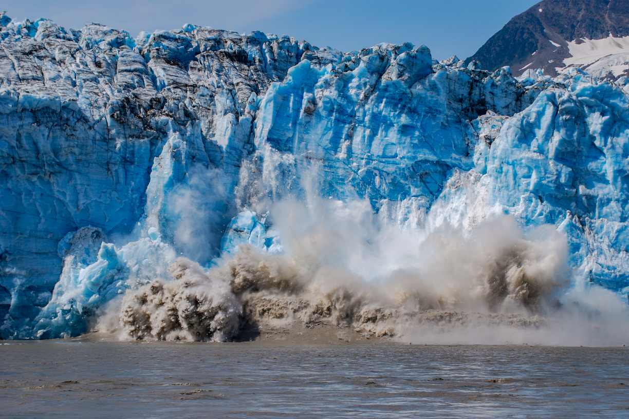
When we first came to Alaska back in 2009, you could still make the 49 mile drive from Cordova to the Million Dollar Bridge (the Bridge to Nowhere). Across the broad, swift, roily Copper River, massive Childs Glacier towered. We had just completed the Salmon Jam half-marathon. Along with another couple, we rented a car and made the drive out through the vast delta wetlands along a mostly unpaved rough, pot-holed road – Trumpeter Swans, other waterfowl, beaver lodges, bear scat and even a couple of moose along the way, distant mountains, our eyes wide with Alaska wow.
Barbra was our primary photographer in those days. We had identified an area that was active, popping and cracking, sloughing off showers of ice. “That entire face is going to go,” I predicted. Barbra set up the camera on a tripod and programmed it to take a shot every second. (The result was like a stop action film.) Shortly after the above shot was made, a wave of five or six feet came barreling toward us with a speed that caught us off guard. I grabbed the tripod as we scrambled for higher ground. Back in Cordova, upon seeing the photos on our camera a Forest Service Ranger told us we had witnessed a “once in every five years or so event.”
A landscape seen by fewer than 100 living people….
The Hike Up Flattop
There’s a small mountain behind our village. We call it Flattop, though once you reach the peak you find that it is somewhat rounded. Although reaching the summit constitutes an elevation gain of only about 1,200 feet (a quarter of a mile; four football fields), because it is the foreword-most mountain facing the village, the summit provides an unobstructed 180 degree view sweeping from the corner of Chignik Lake to one’s left where Clarks River enters, down the lake and through the village, and then down the Chignik River all the way across the estuary to the next village, Chignik Lagoon, a vista encompassing about 12 miles. But in fact, the view is more grand even than that, for one can see mountains 20 miles beyond Chignik Lagoon where a portion of the Alaska Peninsula curves out into the Alaska Gulf, and while gazing across Chignik Lake the landscape disappears in haze over Bristol Bay. Keeping in mind that a few steps beyond the last house in the village one is entering a landscape fewer than 100 living people have seen, the view from Flattop is even more exclusive.
The roundtrip hike from our home to the summit and back is fairly rigorous. We begin by following the community’s main thoroughfare, a dirt road that curves along the lakeshore, crosses a small, willow-crowded stream inhabited by char, and then branches off to the left past a few houses beyond which is a honda trail. For about two miles, the trail alternately cuts through stands of scrub alder and willow, open tundra, and shoulder-high grasses, fireweed, ferns and salmonberry brakes.
The trailhead leading up Flattop is easy to miss if you don’t know where to look. People – young men who are hard on their machines – very occasionally take their quads up the mountain, though scarcely often enough to beat back the jungle-thick vegetation waiting to reclaim any seldom-used path in this part of the world. Not long ago, a neighbor was lucky to get clear in time to avoid injury when the mountain took control of his honda. His quad is now somewhere on Flattop’s steep flanks, hung up in alders, unrecoverable. One’s own two feet are the more prudent – and satisfying – option for ascent.
In the early morning of September 17, we entered the trailhead through a field of tall grasses and fireweed gone to downy seed, colored with autumn, made dripping wet with low fog. As we gained elevation, the grasses, ferns and flower stalks gave way to thick stands of salmonberry bushes. It wasn’t long before our pants were soaked and our water-resistant boots were saturated through to squishy socks. Sunshine in the forecast promised dry clothing once we climbed beyond the vegetation.
Landmark by landmark, salmonberry brakes began to thin. Alders grew smaller and more wind-twisted. We ambled through openings where, back in early June, we’d come across patches of heathers and wildflowers – vaccinium, geranium, yarrow, paintbrush, candle orchid, fireweed. At times we lost the faint trail, the path buried in tall, thick grasses or barely discernible through tangled tunnels of gnarled alders. Just as the sun broke free from mist and crested the summit we emerged onto the first treeless scree, the sudden warmth and open landscape a joy, handfuls of lingonberries, tart, sweet, energizing.
As we continued up the slope, I studied the loose scree for signs of the Weasel Snout, lousewort, Alpine Azalea, Alp Lily, Pincushion, Moss Campion, Roseroot, avens, saxifrage and Purple Oxytrope I’d photographed in June, but aside from a few lupine still clinging to periwinkle-colored blooms, the rest were gone, the few remaining leaves various hues of yellow, red and orange. Near the top we were surprised to find blueberries, wind-stunted bushes hugging thin soil, leaves crimson, berries big and frost-nipped sweet.
We had chosen a day when the forecast predicted calm air, offering the hope of mountains mirrored in a glassy lake and pleasant loafing at the top. We scanned the lakeshore and flats for moose and other wildlife, but aside from a few Black-capped Chickadees, Pine Grosbeaks, a sparrow or three and clouds of midges dancing in filtered sunlight, animals were scarce, though near the summit my spirit bird, a Northern Shrike, materialized from out of nowhere to hover a few feet above my head in order to puzzle me out. Bear tracks all the way at the top. Moose tracks and fox tracks along the way. Lynx scat… maybe.
The video is best viewed on a large screen. As you watch, notice the round, snow-crowned summit just barely peaking out from behind foreground mountains in the view across the lake. That’s Mount Veniaminof, an occasionally active volcano 24 miles southwest of Chignik Lake. The earth’s curve over that distance causes it to appear to be only as tall as the closer 3,000 foot peaks. But in fact, Veniaminof touches the sky at 8,225 feet. We hear it rumble from time to time and have occasionally woken to a smoke-clouded sky or a fine dusting of volcanic ash on new snow in the village.
The corner of the lake to the left, in front of those mountains, is where Clarks River debouches. A major salmon spawning tributary, in September Clarks offers spectacular, nearly untouched fly-fishing for returning Coho Salmon.
Then, looking up the lake through the gap in the hills and mountains, the landscape disappears into haze. Black River flows into Chignik Lake here, beyond which is miles of Black River itself, and then the upper lake, Black Lake. Past that is a vast area of boggy tundra and kettle ponds all the way across the peninsula to the ghost village of Ilnik and the coast where sandy barrier islands, The Seal Islands, front Bristol Bay.
Following the landscape to the right, the lake narrows as it flows past the village of Chignik Lake, a community of about 50 to 55 people, most of whom are of Alutiiq heritage. The large white buildings in the middle are the school gym (left) and the school itself (right) where Barbra teaches. Just as the village ends, the lake narrows further, picks up speed and becomes Chignik River. A narrow dirt road follows the river downstream and terminates at a boat landing across from the fish-counting weir, the buildings of which are just barely visible. There are no roads beyond this one, which terminates on its other end at the airfield.
I included a photograph looking downriver and across the estuary, locally referred to as the lagoon. The image zooms in on the village of Chignik Lagoon, the community closest to Chignik Lake. With no roads nor even trails linking the communities, the river and estuary serve as the highway. Virtually everyone in The Chigniks owns a skiff or two.
The end credits roll over a black and white photograph I made from Flattop’s summit in early June.
Hiking with us on this day were school faculty members new to The Lake: Melody Wiggins, Jacob Chapman and Melody’s son, Micah. Barbra is on the right in the group photo.
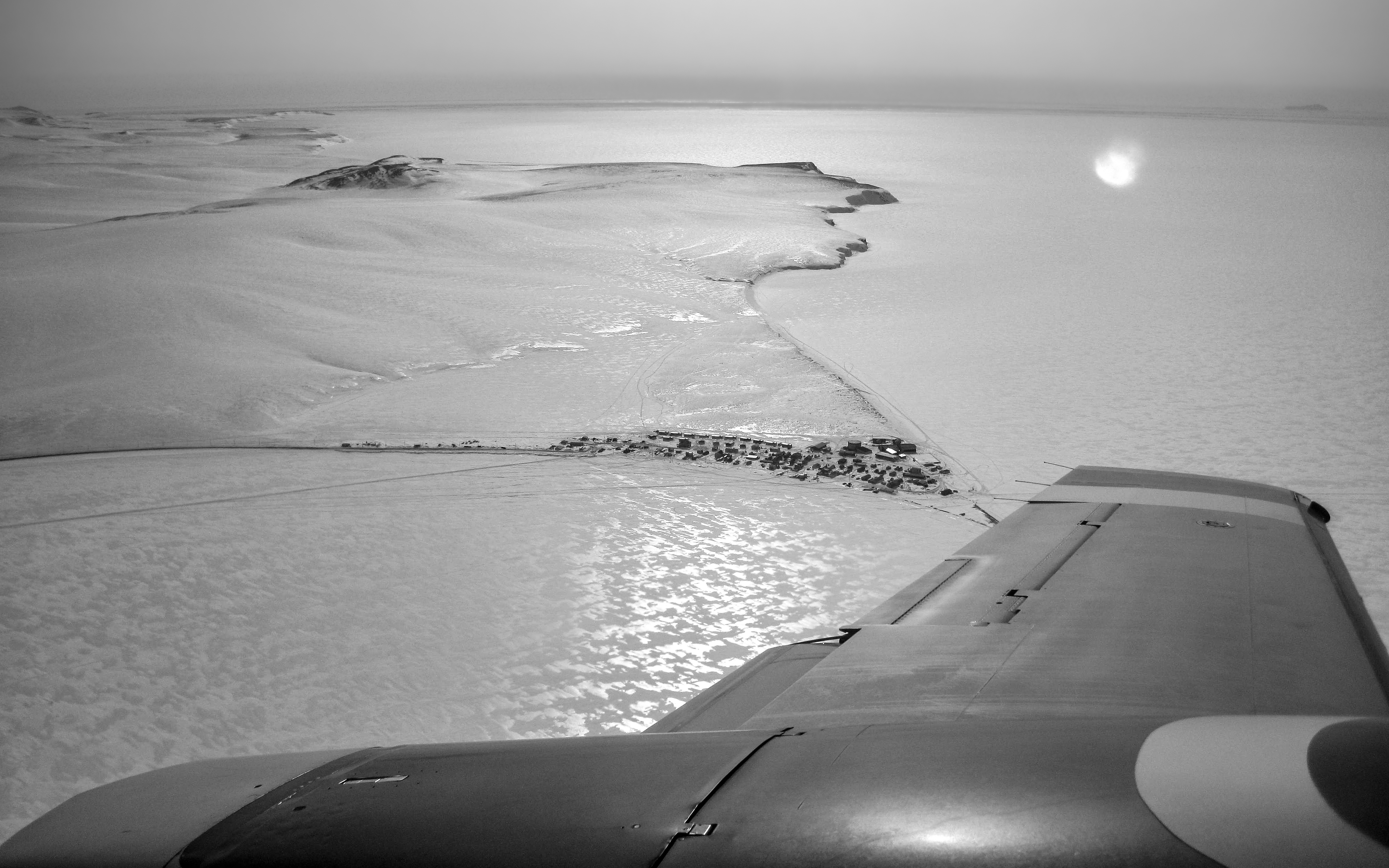
February 13, 2011: Flying into Shishmaref. Situated on the Seward Peninsula Near Bering Land Bridge National Preserve, Sarichef, the sandy barrier island upon which Shishmaref is located, is just 2.8 square miles and shrinking. The highest point above sea level is perhaps just over 20 feet. In the photo a frozen lagoon in the foreground and a frozen Chukchi Sea in the background surround this village of fewer than 600 Inupiat inhabitants. The nearby tundra provides wild berries, caribou, musk ox and moose. The seashore waters and a nearby river provide sea run char and salmon. Seals are also hunted and relied upon for subsistence. This is one of the few places in the world where one can reliably encounter McKay’s Buntings. For nine months from late August 2010 through May 2011 we made our home here. It was a fascinating introduction to Alaska.
One of the great privileges in our life was to live for three years in the Inupiat village of Point Hope, Alaska. Lying 200 miles north of the Arctic Circle and still deeply connected to a whaling-based subsistence culture, it is said that the Tikigaq Peninsula has been inhabited for some 9,000 years, making it one of the oldest continuously inhabited sites in North America. It is a place of aqpik berries and caribou, snowy owls and arctic foxes, fierce winds and frozen seas, a full month of darkness and the most magically soft pink, gold and orange morning and evening light we’ve ever seen. One day in early fall we hiked out to the end of the peninsula, stood on the beach, and watched in wonder as thousands upon thousands of murres, puffins, auklets and other seabirds streamed by on their way to the open ocean to spend the winter, their nesting season complete – surely one of the planet’s greatest migratory events. We endured a mid-winter three-day blow of hurricane force winds that forced most of the village to huddle together in the school which had its own generating system and could offer warm shelter and hot meals. Polar bears sauntered through the village right past our house and there were nights when the Northern lights danced above our heads in electric greens, pinks, purples and reds. And it was a place of friends, some of the toughest, most generous people we’ve ever known. Tikiġaġmiut – the people of this peninsula in the Chukchi sea.
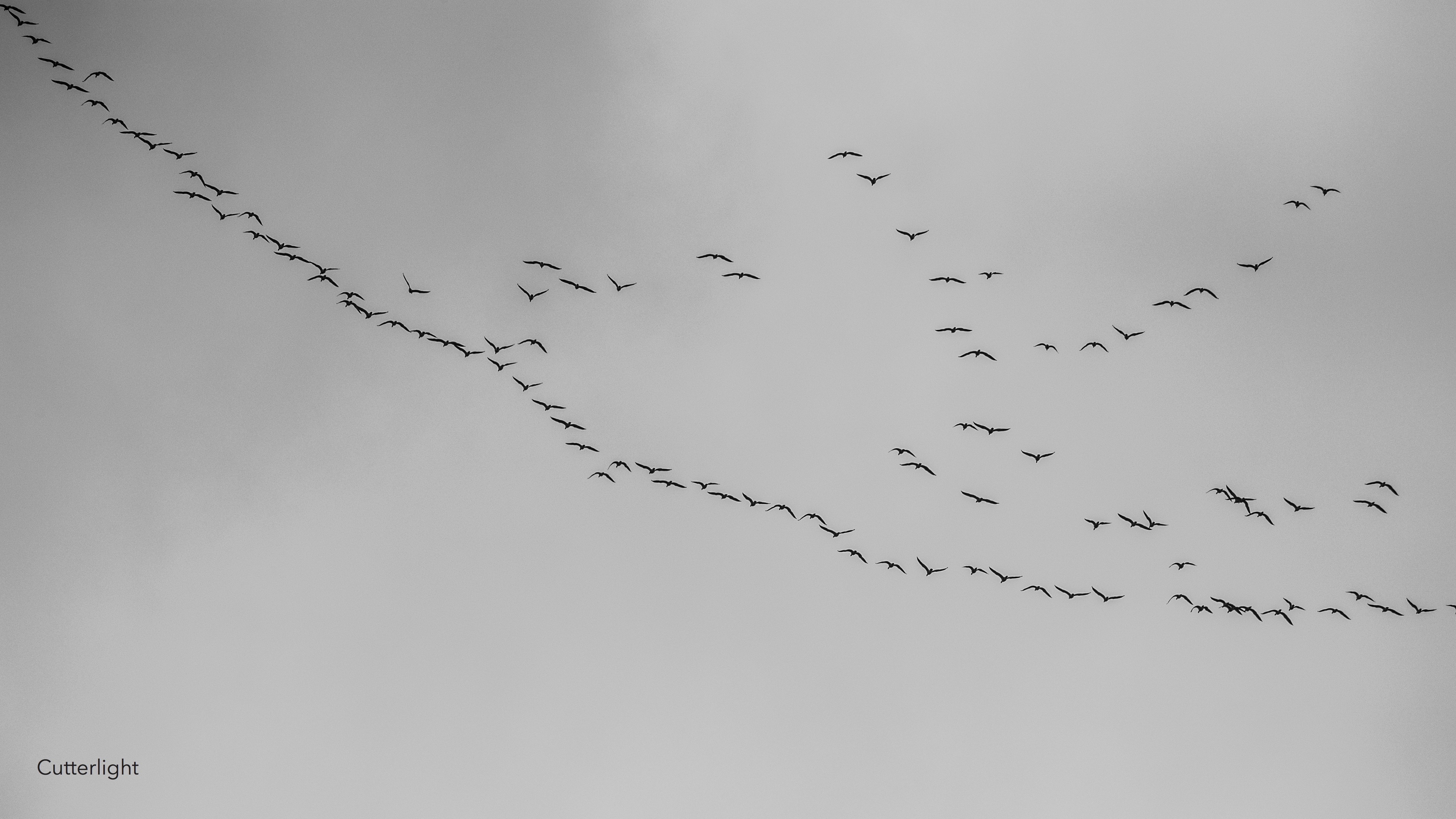
The big picture window with a view across the lake was open just enough when the first group came through. Honking, chattering, noisy, at first distant then growing closer and then distant again till a silence was left where they had been. When the next group came through, I scrambled from behind my desk and dashed out the door, searching the morning’s gray sky till their thin, fluid lines came into view, sentences of sorts arcing northwest toward the big bays on the other side of the peninsula – Mud, Henderson, Nelson’s Lagoon – waters far from any town or village, remote even by standards up here.
All morning it was like that, wave upon wave of Canada Geese having decided that this was the day. When Barbra and I went for an evening walk, they were still coming, clamorous, easy to identify in the good light with their clean black heads and necks and bright white chins against the blue sky.
That night I opened the bedroom window a little, lay on my back not wanting to sleep, listening as the geese continued to write their way home even in the dark.