Camel Skull, Gobi Desert, Mongolia, October 18, 2014
A dzud (zud, зуд) is a weather-related phenomenon in arid parts of central Asia. It could be heavy snow or ice; or a lack of snow or rain; severe cold; drought. Any widespread weather pattern that prevents livestock from obtaining sufficient food or water. Mass deaths… and economic disaster for the semi-nomadic families who follow their animals – goats, sheep, yaks, camels, horses – from place to place across steppelands, grasslands and desert. Roughly a third of Mongolia’s 3.3 million people live this life – among the world’s last nomadic herdsman.
We came across this herdsman tending goats in Khustai National Park, Mongolia. August 7, 2013
I rendered this as both a monochrome and a color image – a coin flip as to which I prefer.
I’d been interested… very interested… in photography ever since my early teens, but I didn’t pick up a camera and use it in any meaningful way until we traveled to Arctic Alaska, four years prior to the above photograph. I could have benefitted – perhaps a great deal – from a formal course of study in the subject. I guess. I’m not sure. Generally speaking, there are both benefits and drawbacks imbedded in the process of learning from others; just as there are benefits and drawbacks to learning on one’s own. Despite four years of somewhat purposeful shooting in Alaska, when we arrived in Mongolia I still didn’t really understand how a camera works. Nor did I have a vision of what kind of images I hoped to make. But once in a while I saw something I liked and I did what I could to make a capture… camera settings often somewhat randomly chosen, insufficient thought and visualization as to what the final, retouched image might look like (or what I hoped it would look like)… and any time a human subject was involved, struggling to overcome what is at times almost crippling shyness and apprehension on my part in order to get the picture. Often failing to overcome that apprehension and letting the moment pass.
So the question remains: Would I have benefitted from, for example, attending formal classes in photography at a respected institution under the guidance of expert instructors? Well, yes, for certain in regards to speeding up my learning curve with respect to technical and scientific aspects as to how a camera works and how film or an image sensor interprets light, and to gain a better understanding of the interplay between camera bodies and lenses. I read, on my own, and viewed a number of instructional videos addressing these subjects… and can report that while they were somewhat helpful, there is a lot of misinformation, and incomplete information, and misleading information on these matters – much of it dispensed by experts and by people who present themselves as experts. People who perhaps know what they are talking about or writing about, but who are not teachers and who don’t know how to teach and who have a difficult time imagining or understanding what a student needs to know… or how a student will receive and apply a given piece of information. Setting that aside, I suppose the answer is probably “Yes,” I – or anyone new to photograph – would benefit from interactive instruction where the primary purpose is to acquire knowledge of how a camera works and how light works and how a camera interprets light.
I suspect such a course of study would be helpful in the same way that prior to writing a novel or a magazine article, it’s necessary to have acquired an understanding of punctuation, syntax, paragraph structure and plot. Understanding basic structures – in any endeavor – can spare one from a lot of fumbling around.
But I wonder if, after 10,000 hours of mindful practice (a concept toward mastery I fundamentally accept), the person who began the journey initially studying under a master doesn’t end up more or less at the same place as the person who embarked alone, and vice versa. After all, whether the matter at hand is photography, writing or fly-fishing, once basic skills are acquired it is left to each individual to determine their own path as to how they hope to develop those skills. Realistic or conceptual; poetry or prose; salmon rivers or saltwater flats.
A problem with instruction beyond basic concepts is that it can end up creating a box around the student.
So… I think that, if it’s an option, by all means find someone from whom to learn the fundamentals – in any endeavor. But don’t linger there. Get the basics. And then go out and put them to use… learning more basics along the way, but more importantly, freeing oneself to pursue one’s own passions and to thereby develop one’s own vision.
I suppose the main thing, in any endeavor, is simply to get started.
On a Frozen Sea, the two of us, April 14, 2013, near Point Hope, Alaska. This is about two miles from the village of Point Hope on a trail broken through huge chunks of ice, as seen, and marked here with a hook.Sea ice here is several feet thick – safe enough, but several of our local friends had stories about getting temporarily stranded when the ice they were on ice broke free from the main sheet. The gun is a precaution against Polar Bears.
I’ve enjoyed going back through photographs from our four years in Arctic Alaska. Although there are a number of additional pictures I’m reasonably happy with, the truth is that most of the images we made in those years constitute memories rather than art. As self-taught photographers, we still had a lot to learn about light, and how cameras interpret light, and composition, and optimal camera settings, lens choices and technique. Moreover, the images we made in those early days have a somewhat random feel about them as we hadn’t yet developed a vision for how we wanted to shoot and what we wanted to make images of… what stories we wanted to tell. We’d love to go back and revisit those scenes, and from time to time we discuss the possibility… but as Frost warned, way leads to way.
When we left Point Hope in the spring of 2014, we traveled to Mongolia where we lived for the following two years. We’re looking forward now to revisiting that collection. So, we hope to see you “in Mongolia!” JD
Looking out across the Chukchi Sea from the very tip of Tikigaq Peninsula. Near Point Hope, Alaska, August 12, 2012.
It was a two-and-a-half mile walk from our home in Point Hope to the terminal point of Tikigaq Peninsula where it hooked into the Chukchi Sea. Cape Lisburne lay to the north; other rocky sea cliffs lay to the southeast. Dense colonies of seabirds – murres, puffins, various ducks, gulls and other birds – nested in these natural sanctuaries, and if you stood at the tip of the peninsula you could watch the adult birds fly back and forth all day long in the summer, in one direct bills and bellies empty, on the return their bellies crammed full of food and what they couldn’t fit in their bellies hanging from their bills. Sand Lances and other fish to be presented to nesting mates and offspring. It was a difficult hike out, a good bit of it along a pebbled beach. At that time in our lives we hadn’t yet made a study of wildflowers, but they were abundant and brightened the path. And you never new when you might come across an Arctic Fox, a Snowy Owl or something else of interest.
Hiking for any distance along a sand beach becomes work, and If you’ve ever walked far along a pebbled beach you know that pebbles make for an even more arduous hike. The ocean breeze was almost always cold at that latitude above the Arctic Circle.
Wishing at times to travel light, we did not always take camera gear.
Which was, of course, a mistake.
One morning in early fall, we arrived at the point and – not knowing what we were in for – found ourselves looking out at more birds than we had ever in our lives seen. Quite probably, more than we will ever see again. Wave upon wave of puffins, murres, kittiwakes, shearwaters and I don’t know what else were streaming out from the cliffs and capes, chicks fledged, the season over. Most of these seabirds would not return to land again until the following spring when they would begin a new nesting season. We had seen films depicting African migrations of wildebeests and other ungulates, and in Alaska of great herds of caribou, and those films were called to mind. I once, in Kentucky, found myself amidst a late spring migration of Box Turtles; I pulled my car to the shoulder and assisted over a dozen of them safely across the country road I was traveling. If I had that to do over, I’d have stayed for as long as it took and helped more…
Surely that morning on the tip of Tikigaq, Barbra and I were witness to one of the world’s greatest migration events. We felt, suddenly, a deep connection with… something… overwhelming. Thoreau’s contact, or a final couplet from Wordsworth:
To me the meanest flower that blooms can give Thoughts that lie too deep for tears.
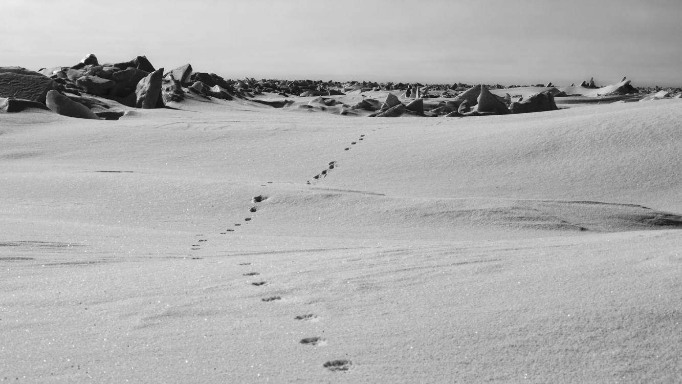
Polar Bear tracks disappear into the other worldly landscape of ice and snow on the frozen Chukchi Sea near Point Hope. The great bears continuously roam the ice in search of seals and the remains of whales that have been caught. By average weight, Polar Bears rank as the world’s largest bear. However, the Coastal Brown Bears of Kodiak Island and the Chignik River drainage on the Alaska Peninsula can weigh as much and stand taller. April 26, 2012
Engraved with a cross and reaching into the sky, the jawbone of a Bowhead Whale stands sentinel over a grave buried in spring snow at Point Hope, Alaska. April 12, 2012
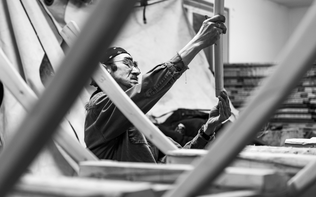
Artist and boatwright Henry “Hanko” Koonook at work on an umiak in his shop. The keel, thwarts and each wooden rib is hand fashioned and precisely fitted. When the frame is finished, it will be covered with the stretched skin of an ugruk (bearded seal). This will be the boat’s hull. Traditional skin boats such as these are still used by Inupiat whaling crews in Point Hope and other villages of the far north. Long may it be so. Point Hope, Alaska, March 21, 2013.
This umiak – a traditional whaling boat, the hull made of Bearded Seal skin stretched tight and lashed over wooden ribs – was positioned on a rack, allowing me to make a photograph of the inside, upside down. Point Hope, Alaska, March 27, 2012.
Ghost village ruins of an Inupiat home constructed from ship timbers, sod and the bones of Bowhead Whales. Tikigaq, Alaska September 3, 2011
Saltwater inundation caused by an encroaching sea forced the people of Point Hope to relocate further inland down Tikigaq Peninsula a few decades ago, but I am told that as recently as the 1970’s a few people still inhabited homes such as the one above. In fact, on at least one such structure we saw, there was a junction box for electricity. Along with these igloos (a term which refers not just to structures made of ice, but to any dome-shaped Inupiat dwelling), there were other more familiar-looking homes in old Tikigaq, but those too have long been abandoned to decay back into the Arctic tundra.
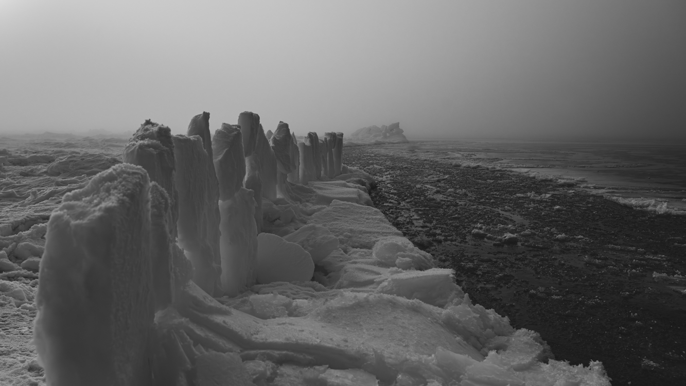
Three miles out on the frozen Chukchi Sea, 125 miles north of the Arctic Circle, thick fog lifts to reveal slabs of ice positioned by Inupiat whalers to serve as a hunting blind along the edge of a slushy lead. Both Bowhead and Beluga Whales are taken as they migrate through these open lanes between sheets of ice.Near Point Hope. Alaska, May 3, 2012